1990s Maps of Pickens County, South Carolina
Explore 4 historic maps of Pickens County from the 1990s. These maps offer a rare glimpse into what life looked like during the 1990s — showing old roads, neighborhoods, homes, and landmarks that have changed or disappeared over time.
Whether you're researching your family's past, planning a metal detecting trip, or studying how Pickens County's landscape evolved across the 1990s, these high-resolution maps are a powerful tool for exploring the history of this region.
- Focus on a specific era: All maps on this page are from the 1990s, giving you a focused view of this time period.
- See what’s changed: Compare century-old streets, trails, and buildings to today's modern landscape using overlays and satellite layers.
- Research with precision: Use these maps for genealogy, historical research, land use analysis, or educational projects.
- View, download, or print: Maps are fully viewable online in high resolution, and can be downloaded or printed for your own records.
Start exploring Pickens County's history through authentic maps from the 1990s. This is your window into the past.
Pickens County, SC maps
(4)- 1991 Map of Greenville
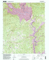
 1991 Greenville1991 Print · USGSThe South Carolina Upstate was a landscape of rapid growth and engineering in the early nineties. Researchers can trace the expansion of Greenville and Spartanburg, find Clemson University, or study the massive reservoirs of Hartwell Lake and Lake Keowee.
 - 1996 Map of Salem, 2000 Print
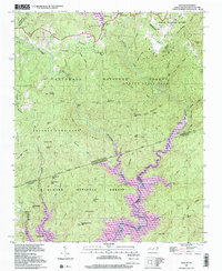
 1996 Salem2000 Print · USGSThe foothills of the Blue Ridge were being reshaped by massive reservoir projects when this survey was finalized in the late nineties. Genealogists can trace family sites near Salem and rural landmarks like Piney Grove Ch and McKinney Chapel.
 - 1997 Map of Eastatoe Gap, 2001 Print
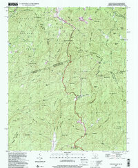 1997 Eastatoe Gap2001 Print · USGSTransylvania County's mountain passes and mid-century topography are detailed here in the late nineties, documenting the area's transition into the modern era. Trace the path of the Blue Ridge Parkway or locate local landmarks like Camp Adger and Chimneytop.
 - 1997 Map of Reid, 2001 Print
 1997 Reid2001 Print · USGSThe Blue Ridge high country is captured here in the late nineties, documenting the rugged borderlands between North and South Carolina. Researchers can trace family sites near Oakland, find the Oakland Cem, and locate landmarks like Toxaway Falls.
End of results
Showing maps 1-4 of 4
Top cities of Pickens County
- Easley historical maps
- Clemson historical maps
- Central historical maps
- Liberty historical maps
- Pickens historical maps
- Norris historical maps
See more
Frequently asked questions
- What are the different types of historical maps available for Pickens County?
- What is the oldest map of Pickens County?
- Where can I purchase historical maps of Pickens County for my home or office?
- Where can I download high-res historical maps of Pickens County?
- Are there historical topographic maps available for Pickens County?
- Is there historical aerial imagery available for Pickens County?
- Where are historical maps of Pickens County sourced from?