1980s Maps of Pickens County, South Carolina
Explore 9 historic maps of Pickens County from the 1980s. These maps offer a rare glimpse into what life looked like during the 1980s — showing old roads, neighborhoods, homes, and landmarks that have changed or disappeared over time.
Whether you're researching your family's past, planning a metal detecting trip, or studying how Pickens County's landscape evolved across the 1980s, these high-resolution maps are a powerful tool for exploring the history of this region.
- Focus on a specific era: All maps on this page are from the 1980s, giving you a focused view of this time period.
- See what’s changed: Compare century-old streets, trails, and buildings to today's modern landscape using overlays and satellite layers.
- Research with precision: Use these maps for genealogy, historical research, land use analysis, or educational projects.
- View, download, or print: Maps are fully viewable online in high resolution, and can be downloaded or printed for your own records.
Start exploring Pickens County's history through authentic maps from the 1980s. This is your window into the past.
Pickens County, SC maps
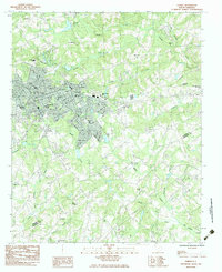
(9)- 1983 Map of Liberty
 1983 Liberty1983 Print · USGSThe Southern railway corridor and Piedmont foothills define this part of Pickens County in the early eighties. Researchers can trace family sites at Rices Creek Ch, locate the old Drive-In Theater, or survey the grounds of Hillcrest Memorial Park.2 unique versions available
 - 1983 Map of Easley
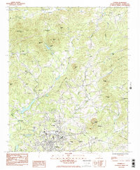
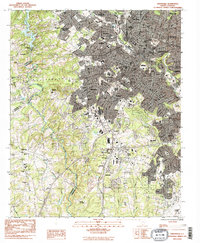
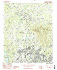
 1983 Easley1983 Print · USGSEasley and its surrounding rural communities are captured here in the early eighties, showcasing the area's growth along the Southern railroad. Genealogists can locate numerous local landmarks like Three and Twenty Ch, Rock Spring Ch, and the McKissick Sch.
 - 1983 Map of Dacusville
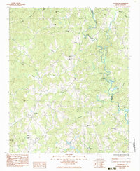 1983 Dacusville1983 Print · USGSDacusville and the surrounding Piedmont hills are captured here in the early eighties, showing a landscape of family-named ridges and rural congregations. Researchers can trace local heritage at sites like Nine Forks Ch, Hunts Memorial Ch, and the settlement at Doddies.
 - 1983 Map of Five Forks
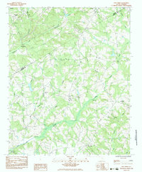 1983 Five Forks1983 Print · USGSThe borderlands of Pickens and Anderson Counties are captured here in the early 1980s, revealing a landscape of small Piedmont communities and deep-rooted rural institutions. Genealogists can trace ancestral sites at Willis Chapel Cem, Sharon Ch, and along the banks of Three and Twenty Creek.
 - 1983 Map of Pickens
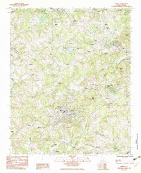
 1983 Pickens1983 Print · USGSThe foothills of the Blue Ridge come alive in the early 1980s as the town of Pickens expands toward the northern ridges. Genealogists can trace a remarkable density of local landmarks, from the Oolenoy Ch and Bethany Ch to the slopes of Glassy Mtn.2 unique versions available
 - 1983 Map of Greenville
 1983 Greenville1983 Print · USGSGreenville and its surrounding textile and rail suburbs are captured here in the early eighties. Researchers can trace family history through dozens of landmarks like Sirrine Stadium, the Judson Cem, and the Donaldson Center Airport.2 unique versions available
 - 1983 Map of Paris Mountain
 1983 Paris Mountain1983 Print · USGSThe northern Greenville suburbs and the gateway to the mountains are captured here in the early eighties. Genealogists and historians can trace the footprint of Furman University and local congregations at Ebenezer Ch and St Lukes Ch.3 unique versions available
 - 1984 Map of Greenville
 1984 Greenville1984 Print · USGSThe South Carolina Upstate undergoes rapid suburban growth in the mid-eighties as modern interstates begin to reshape the landscape. Researchers can trace historic rail lines like the Greenville and Northern Railway and locate local landmarks such as Clemson University and Paris Mountain State Park.
 - 1986 Map of Hendersonville
 1986 Hendersonville1986 Print · USGSThe Blue Ridge foothills of North and South Carolina are documented here in the mid-eighties as modern highways began to reshape mountain travel. Local historians can trace the paths of the Southern Railway through Hendersonville or locate landmarks like Looking Glass Rock and Inman Mills.2 unique versions available
End of results
Showing maps 1-9 of 9
Top cities of Pickens County
- Easley historical maps
- Clemson historical maps
- Central historical maps
- Liberty historical maps
- Pickens historical maps
- Norris historical maps
See more
Frequently asked questions
- What are the different types of historical maps available for Pickens County?
- What is the oldest map of Pickens County?
- Where can I purchase historical maps of Pickens County for my home or office?
- Where can I download high-res historical maps of Pickens County?
- Are there historical topographic maps available for Pickens County?
- Is there historical aerial imagery available for Pickens County?
- Where are historical maps of Pickens County sourced from?