1980s Maps of Campobello, South Carolina
Explore 4 historic maps of Campobello from the 1980s. These maps offer a rare glimpse into what life looked like during the 1980s — showing old roads, neighborhoods, homes, and landmarks that have changed or disappeared over time.
Whether you're researching your family's past, planning a metal detecting trip, or studying how Campobello's landscape evolved across the 1980s, these high-resolution maps are a powerful tool for exploring the history of this region.
- Focus on a specific era: All maps on this page are from the 1980s, giving you a focused view of this time period.
- See what’s changed: Compare century-old streets, trails, and buildings to today's modern landscape using overlays and satellite layers.
- Research with precision: Use these maps for genealogy, historical research, land use analysis, or educational projects.
- View, download, or print: Maps are fully viewable online in high resolution, and can be downloaded or printed for your own records.
Start exploring Campobello's history through authentic maps from the 1980s. This is your window into the past.
Campobello, SC maps
(4)- 1983 Map of Campobello
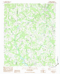 1983 Campobello1983 Print · USGSThe Greenville and Spartanburg borderlands appear here in the early 1980s, centered on the railroad town of Campobello. Genealogists and local historians can trace rural family landmarks like Pleasant Grove Cemetery and old country churches including Motlow Creek Church and Mt View Church.
 - 1983 Map of Fingerville West
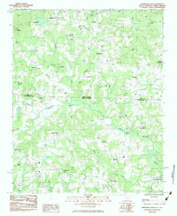 1983 Fingerville West1983 Print · USGSThe Carolina borderlands come alive in this early 1980s survey of the Spartanburg and Polk County area. Researchers can trace rural lineages through local landmarks like Little Africa, New Prospect, and historic congregations such as Melvin Hill Ch.
 - 1983 Map of Landrum
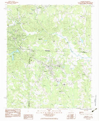 1983 Landrum1983 Print · USGSThe foothills of the Carolinas come alive in this early 1980s survey of the borderlands between North and South Carolina. Trace the rail-and-road corridor through Landrum and Tryon, or locate family landmarks like Fellowship Ch, Oak Grove Ch, and Burnt Chimney Corner.
 - 1986 Map of Hendersonville
 1986 Hendersonville1986 Print · USGSThe Blue Ridge foothills of North and South Carolina are documented here in the mid-eighties as modern highways began to reshape mountain travel. Local historians can trace the paths of the Southern Railway through Hendersonville or locate landmarks like Looking Glass Rock and Inman Mills.2 unique versions available
End of results
Showing maps 1-4 of 4
Top cities near Campobello
- Spartanburg historical maps
- Greer historical maps
- Wade Hampton historical maps
- Lyman historical maps
- Rutherfordton historical maps
- Spindale historical maps
See more
Top neighborhoods of Campobello
Frequently asked questions
- What are the different types of historical maps available for Campobello?
- What is the oldest map of Campobello?
- Where can I purchase historical maps of Campobello for my home or office?
- Where can I download high-res historical maps of Campobello?
- Are there historical topographic maps available for Campobello?
- Is there historical aerial imagery available for Campobello?
- Where are historical maps of Campobello sourced from?