1980s Maps of Spartanburg, South Carolina
Explore 3 historic maps of Spartanburg from the 1980s. These maps offer a rare glimpse into what life looked like during the 1980s — showing old roads, neighborhoods, homes, and landmarks that have changed or disappeared over time.
Whether you're researching your family's past, planning a metal detecting trip, or studying how Spartanburg's landscape evolved across the 1980s, these high-resolution maps are a powerful tool for exploring the history of this region.
- Focus on a specific era: All maps on this page are from the 1980s, giving you a focused view of this time period.
- See what’s changed: Compare century-old streets, trails, and buildings to today's modern landscape using overlays and satellite layers.
- Research with precision: Use these maps for genealogy, historical research, land use analysis, or educational projects.
- View, download, or print: Maps are fully viewable online in high resolution, and can be downloaded or printed for your own records.
Start exploring Spartanburg's history through authentic maps from the 1980s. This is your window into the past.
Spartanburg, SC maps
(3)- 1983 Map of Spartanburg
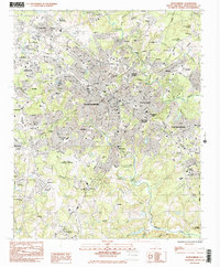 1983 Spartanburg1983 Print · USGSSpartanburg during the early 1980s reveals a bustling Piedmont city anchored by its prestigious colleges and industrial suburbs. Researchers can trace the development of the city's residential districts like Converse Heights or locate family sites near Lincoln Memorial Gardens and Drayton.2 unique versions available
 - 1983 Map of Pacolet
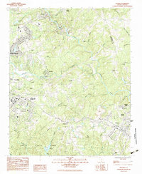 1983 Pacolet1983 Print · USGSEastern Spartanburg County is documented here in the early eighties as mill towns and rural communities centered on the river. Trace family history at Bagwell Cem, explore the early boundaries of Camp Croft State Park, or locate the textile centers of Glendale and Pacolet Mills.2 unique versions available
 - 1986 Map of Spartanburg
 1986 Spartanburg1986 Print · USGSUpstate South Carolina is captured here in the mid-1980s, showcasing the region's transition from a textile-driven rail corridor to a modern interstate hub. Researchers can trace the legacy of the SOUTHERN railroad through mill towns like Glendale or explore the wooded reaches of the Sumter National Forest.2 unique versions available
End of results
Showing maps 1-3 of 3
Top cities near Spartanburg
- Gaffney historical maps
- Lyman historical maps
- Woodruff historical maps
- Inman historical maps
- Duncan historical maps
- Pacolet historical maps
See more
Top neighborhoods of Spartanburg
- Arkwright historical maps
- Montgomery Acres historical maps
- East Spartanburg historical maps
- Arbours historical maps
- Cypress Creek historical maps
- Webber Place historical maps
See more
Frequently asked questions
- What are the different types of historical maps available for Spartanburg?
- What is the oldest map of Spartanburg?
- Where can I purchase historical maps of Spartanburg for my home or office?
- Where can I download high-res historical maps of Spartanburg?
- Are there historical topographic maps available for Spartanburg?
- Is there historical aerial imagery available for Spartanburg?
- Where are historical maps of Spartanburg sourced from?