1970s Maps of Sumter County, South Carolina
Explore 4 historic maps of Sumter County from the 1970s. These maps offer a rare glimpse into what life looked like during the 1970s — showing old roads, neighborhoods, homes, and landmarks that have changed or disappeared over time.
Whether you're researching your family's past, planning a metal detecting trip, or studying how Sumter County's landscape evolved across the 1970s, these high-resolution maps are a powerful tool for exploring the history of this region.
- Focus on a specific era: All maps on this page are from the 1970s, giving you a focused view of this time period.
- See what’s changed: Compare century-old streets, trails, and buildings to today's modern landscape using overlays and satellite layers.
- Research with precision: Use these maps for genealogy, historical research, land use analysis, or educational projects.
- View, download, or print: Maps are fully viewable online in high resolution, and can be downloaded or printed for your own records.
Start exploring Sumter County's history through authentic maps from the 1970s. This is your window into the past.
Sumter County, SC maps
(4)- 1971 Map of Summerton
 1971 Summerton1971 Print · USGSThe Clarendon County countryside comes alive in this mid-century survey, showing the transition from the Poinsett forest to the shores of Lake Marion. Genealogists can trace family roots through numerous local landmarks like Wells Sch, St Pauls Ch, and the historic Fort Watson.2 unique versions available
 - 1973 Map of Elliott, 1974 Print
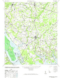
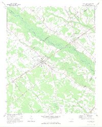
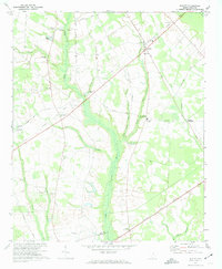 1973 Elliott1974 Print · USGSIn the early 1970s, the Lee County interior centered on a network of traditional rural hubs and church-centered communities. Researchers can trace family-named sites like Mattie Js Pond or locate historic congregations such as St Sinai Ch and Unionville Ch.2 unique versions available
 - 1973 Map of Lynchburg, 1975 Print
 1973 Lynchburg1975 Print · USGSLynchburg and the surrounding rural communities thrive along the banks of the Lynches River in the early seventies. Genealogists and historians can trace family roots at St Matthews Ch, locate the Hawkins Cem, or follow the path of the Old Stagecoach Road.
 - 1974 Map of Georgetown, 1978 Print
 1974 Georgetown1978 Print · USGSThe Carolina coast and Pee Dee region are shown here in the mid-seventies, just as the Grand Strand was maturing into a premier destination. Researchers can trace the inland rail corridors of the Seaboard Coast Line Railroad or explore the coastal reaches of the Cape Romain National Wildlife Refuge and Myrtle Beach State Park.2 unique versions available
End of results
Showing maps 1-4 of 4
Top cities of Sumter County
Frequently asked questions
- What are the different types of historical maps available for Sumter County?
- What is the oldest map of Sumter County?
- Where can I purchase historical maps of Sumter County for my home or office?
- Where can I download high-res historical maps of Sumter County?
- Are there historical topographic maps available for Sumter County?
- Is there historical aerial imagery available for Sumter County?
- Where are historical maps of Sumter County sourced from?