1940s Maps of Sumter County, South Carolina
Explore 10 historic maps of Sumter County from the 1940s. These maps offer a rare glimpse into what life looked like during the 1940s — showing old roads, neighborhoods, homes, and landmarks that have changed or disappeared over time.
Whether you're researching your family's past, planning a metal detecting trip, or studying how Sumter County's landscape evolved across the 1940s, these high-resolution maps are a powerful tool for exploring the history of this region.
- Focus on a specific era: All maps on this page are from the 1940s, giving you a focused view of this time period.
- See what’s changed: Compare century-old streets, trails, and buildings to today's modern landscape using overlays and satellite layers.
- Research with precision: Use these maps for genealogy, historical research, land use analysis, or educational projects.
- View, download, or print: Maps are fully viewable online in high resolution, and can be downloaded or printed for your own records.
Start exploring Sumter County's history through authentic maps from the 1940s. This is your window into the past.
Sumter County, SC maps
(10)- 1940 Map of Florence West
 1940 Florence West1940 Print · USGSThe rural landscapes and rail towns west of Florence appear here just before the mid-century, as the local economy revolved around the river and the tracks. Genealogists can trace family roots through numerous country churches like Snow Hill Ch and old settlements like Timmonsville and Ebenezer.2 unique versions available
 - 1941 Map of Spartanburg
 1941 Spartanburg1941 Print · USGSSouth Carolina’s Piedmont and Sandhills regions are shown here during the mid-century peak of the rail era. Researchers can trace the sprawling Fort Jackson Military Reservation and the industrial growth of hubs like Spartanburg and Rock Hill.
 - 1942 Map of Camden
 1942 Camden1942 Print · USGSMid-century South Carolina comes into focus along the Wateree River as the region's rail and agricultural networks reached their peak. Genealogists and historians can trace old community hubs like Boykin Mill, Friends Neck Ch, and the grounds of the Sand Hill Experimental Station.
 - 1943 Map of Mayesville
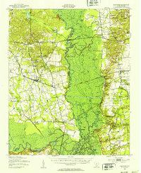
 1943 Mayesville1943 Print · USGSThe rural landscape of Sumter and Clarendon counties is captured here in the 1940s, highlighting a region defined by the Black River swamp. Genealogists can trace early family landmarks and community centers like Mayesville, Gamble Chapel, and the Malina Sch.
 - 1943 Map of Eastover, 1953 Print
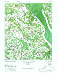
 1943 Eastover1953 Print · USGSIn the early 1940s, the rural landscapes of Richland and Sumter counties centered on the river junctions and thriving rail lines. Genealogists can trace family landmarks like Good Hope Ch and Bethel Sch or follow the path of the Kings Highway.
 - 1945 Map of Florence West
 1945 Florence West1945 Print · USGSInland South Carolina during the mid-1940s is defined here by the converging rails of the Atlantic Coast Line and a network of rural crossroads. Researchers can trace ancestral locations through dozens of landmarks like Anderson Cem, Muldrow Mill, and Syracuse.2 unique versions available
 - 1946 Map of Elloree
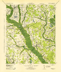
 1946 Elloree1946 Print · USGSCoastal plain settlements and rising reservoir waters define this mid-1940s landscape in the Santee River basin. Genealogists and historians can trace the foundations of Langsynt Plantation, locate numerous rural churches like Mizpah Ch, or study the rail corridor through Lone Star.2 unique versions available
 - 1946 Map of Lake City
 1946 Lake City1946 Print · USGSMid-century Florence and Williamsburg counties are seen here through a network of rural crossroads and river bottomlands just after the war. Researchers can trace family roots at Holly Tree Plantation, Bethany Cem, and dozens of local schools from Olanta to Lake City.
 - 1946 Map of Sumter
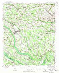
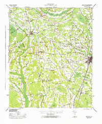
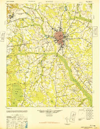 1946 Sumter1946 Print · USGSSumter and its surrounding lowlands were at a peak of rail and aviation development just after the war. Researchers can trace dozens of rural landmarks, from Pocalla Springs and Swan Lake to the sprawling Shaw Field.
 - 1949 Map of Georgetown, 1953 Print
 1949 Georgetown1953 Print · USGSThe South Carolina coast and North Carolina borderlands appear here in the mid-century, prior to the major modern development of the Grand Strand. Genealogists and historians can trace the rail networks of the Seaboard Air Line Railroad and locate coastal landmarks from Fort Caswell to McClellanville.
End of results
Showing maps 1-10 of 10
Top cities of Sumter County
Frequently asked questions
- What are the different types of historical maps available for Sumter County?
- What is the oldest map of Sumter County?
- Where can I purchase historical maps of Sumter County for my home or office?
- Where can I download high-res historical maps of Sumter County?
- Are there historical topographic maps available for Sumter County?
- Is there historical aerial imagery available for Sumter County?
- Where are historical maps of Sumter County sourced from?