1970s Maps of Williamsburg County, South Carolina
Explore 4 historic maps of Williamsburg County from the 1970s. These maps offer a rare glimpse into what life looked like during the 1970s — showing old roads, neighborhoods, homes, and landmarks that have changed or disappeared over time.
Whether you're researching your family's past, planning a metal detecting trip, or studying how Williamsburg County's landscape evolved across the 1970s, these high-resolution maps are a powerful tool for exploring the history of this region.
- Focus on a specific era: All maps on this page are from the 1970s, giving you a focused view of this time period.
- See what’s changed: Compare century-old streets, trails, and buildings to today's modern landscape using overlays and satellite layers.
- Research with precision: Use these maps for genealogy, historical research, land use analysis, or educational projects.
- View, download, or print: Maps are fully viewable online in high resolution, and can be downloaded or printed for your own records.
Start exploring Williamsburg County's history through authentic maps from the 1970s. This is your window into the past.
Williamsburg County, SC maps
(4)- 1974 Map of Georgetown, 1978 Print
 1974 Georgetown1978 Print · USGSThe Carolina coast and Pee Dee region are shown here in the mid-seventies, just as the Grand Strand was maturing into a premier destination. Researchers can trace the inland rail corridors of the Seaboard Coast Line Railroad or explore the coastal reaches of the Cape Romain National Wildlife Refuge and Myrtle Beach State Park.2 unique versions available
 - 1979 Map of Pineville
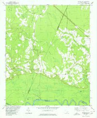
 1979 Pineville1979 Print · USGSIn the late 1970s, this Berkeley County landscape shows the transition from the Santee River swamps to the northern shores of Lake Moultrie. Genealogists can locate the Site of Francis Marion Tomb Cem and numerous local landmarks like Redeemer Ch and the Santee Canal (Abandoned).2 unique versions available
 - 1979 Map of Foreston, 1980 Print
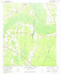 1979 Foreston1980 Print · USGSThe lowlands of Clarendon County are shown here in the late seventies, a landscape defined by the Black River Swamp and unique Carolina bays. Genealogists can locate family landmarks like St Michaels Ch and Biggers Ch, or trace the old Seaboard Coast Line rail route.2 unique versions available
 - 1979 Map of Butlers Bay, 1980 Print
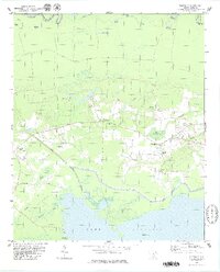
 1979 Butlers Bay1980 Print · USGSClarendon and Williamsburg counties are mapped here in the late seventies as the rural landscape follows the Santee River. Researchers can trace old family sites and rural congregations like Pine Grove Ch and Keels Cem among the wetlands of Butlers Bay.2 unique versions available
End of results
Showing maps 1-4 of 4
Top cities of Williamsburg County
- Kingstree historical maps
- Lane historical maps
- Hemingway historical maps
- Greeleyville historical maps
- Stuckey historical maps
Frequently asked questions
- What are the different types of historical maps available for Williamsburg County?
- What is the oldest map of Williamsburg County?
- Where can I purchase historical maps of Williamsburg County for my home or office?
- Where can I download high-res historical maps of Williamsburg County?
- Are there historical topographic maps available for Williamsburg County?
- Is there historical aerial imagery available for Williamsburg County?
- Where are historical maps of Williamsburg County sourced from?