1980s Maps of Williamsburg County, South Carolina
Explore 4 historic maps of Williamsburg County from the 1980s. These maps offer a rare glimpse into what life looked like during the 1980s — showing old roads, neighborhoods, homes, and landmarks that have changed or disappeared over time.
Whether you're researching your family's past, planning a metal detecting trip, or studying how Williamsburg County's landscape evolved across the 1980s, these high-resolution maps are a powerful tool for exploring the history of this region.
- Focus on a specific era: All maps on this page are from the 1980s, giving you a focused view of this time period.
- See what’s changed: Compare century-old streets, trails, and buildings to today's modern landscape using overlays and satellite layers.
- Research with precision: Use these maps for genealogy, historical research, land use analysis, or educational projects.
- View, download, or print: Maps are fully viewable online in high resolution, and can be downloaded or printed for your own records.
Start exploring Williamsburg County's history through authentic maps from the 1980s. This is your window into the past.
Williamsburg County, SC maps
(4)- 1985 Map of Saint George, 1986 Print
 1985 Saint George1986 Print · USGSThe South Carolina Lowcountry in the mid-eighties shows a landscape defined by the great reservoirs and the meandering Edisto River. Researchers can trace the rail corridors of the Southern Railway and find rural settlements like Harleyville, Smoaks, and Grover.
 - 1986 Map of Georgetown
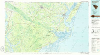 1986 Georgetown1986 Print · USGSThe South Carolina Lowcountry is captured here in the mid-1980s, centered on the historic port of Georgetown and its surrounding wetlands. Researchers can trace the river-fed economy and land patterns of Waccamaw Neck, Hampton Plantation State Park, and the timber-rich Francis Marion National Forest.2 unique versions available
 - 1986 Map of Kingstree
 1986 Kingstree1986 Print · USGSThe South Carolina Lowcountry in the mid-eighties shows a landscape defined by the Black River and the growing coastal communities of the Grand Strand. Researchers can trace historic river settlements and rail stops like Salters Depot, Pamplico, and Hemingway.2 unique versions available
 - 1986 Map of Sumter
 1986 Sumter1986 Print · USGSMid-South Carolina in the mid-eighties reveals a landscape of massive river bottomlands and significant military installations. Genealogists and historians can trace the rural networks around Fort Motte, Lone Star, and Sardinia alongside Lake Marion.
End of results
Showing maps 1-4 of 4
Top cities of Williamsburg County
- Kingstree historical maps
- Lane historical maps
- Hemingway historical maps
- Greeleyville historical maps
- Stuckey historical maps
Frequently asked questions
- What are the different types of historical maps available for Williamsburg County?
- What is the oldest map of Williamsburg County?
- Where can I purchase historical maps of Williamsburg County for my home or office?
- Where can I download high-res historical maps of Williamsburg County?
- Are there historical topographic maps available for Williamsburg County?
- Is there historical aerial imagery available for Williamsburg County?
- Where are historical maps of Williamsburg County sourced from?