1990s Maps of Lane, South Carolina
Explore 2 historic maps of Lane from the 1990s. These maps offer a rare glimpse into what life looked like during the 1990s — showing old roads, neighborhoods, homes, and landmarks that have changed or disappeared over time.
Whether you're researching your family's past, planning a metal detecting trip, or studying how Lane's landscape evolved across the 1990s, these high-resolution maps are a powerful tool for exploring the history of this region.
- Focus on a specific era: All maps on this page are from the 1990s, giving you a focused view of this time period.
- See what’s changed: Compare century-old streets, trails, and buildings to today's modern landscape using overlays and satellite layers.
- Research with precision: Use these maps for genealogy, historical research, land use analysis, or educational projects.
- View, download, or print: Maps are fully viewable online in high resolution, and can be downloaded or printed for your own records.
Start exploring Lane's history through authentic maps from the 1990s. This is your window into the past.
Lane, SC maps
(2)- 1990 Map of Greeleyville
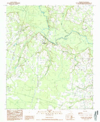
 1990 Greeleyville1990 Print · USGSGreeleyville and the Williamsburg County backcountry are captured in the early nineties as the region’s wetland-driven economy matured. Genealogists and local historians can trace family-named sites across Burgess Bay, Heineman, and the banks of the Santee River.
 - 1990 Map of Salters
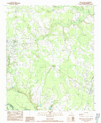
 1990 Salters1990 Print · USGSWilliamsburg County settlements and the Black River basin are captured here in the early nineties, showing a landscape of small crossroads and expansive wetlands. Genealogists and local historians can trace family-named sites like Bryans Crossroads, the town of Lane, and the CSX Transportation rail corridor.
End of results
Showing maps 1-2 of 2
Top cities near Lane
Frequently asked questions
- What are the different types of historical maps available for Lane?
- What is the oldest map of Lane?
- Where can I purchase historical maps of Lane for my home or office?
- Where can I download high-res historical maps of Lane?
- Are there historical topographic maps available for Lane?
- Is there historical aerial imagery available for Lane?
- Where are historical maps of Lane sourced from?