1940s Maps of York, South Carolina
Explore 4 historic maps of York from the 1940s. These maps offer a rare glimpse into what life looked like during the 1940s — showing old roads, neighborhoods, homes, and landmarks that have changed or disappeared over time.
Whether you're researching your family's past, planning a metal detecting trip, or studying how York's landscape evolved across the 1940s, these high-resolution maps are a powerful tool for exploring the history of this region.
- Focus on a specific era: All maps on this page are from the 1940s, giving you a focused view of this time period.
- See what’s changed: Compare century-old streets, trails, and buildings to today's modern landscape using overlays and satellite layers.
- Research with precision: Use these maps for genealogy, historical research, land use analysis, or educational projects.
- View, download, or print: Maps are fully viewable online in high resolution, and can be downloaded or printed for your own records.
Start exploring York's history through authentic maps from the 1940s. This is your window into the past.
York, SC maps
(4)- 1941 Map of Spartanburg
 1941 Spartanburg1941 Print · USGSSouth Carolina’s Piedmont and Sandhills regions are shown here during the mid-century peak of the rail era. Researchers can trace the sprawling Fort Jackson Military Reservation and the industrial growth of hubs like Spartanburg and Rock Hill.
 - 1947 Map of Clover, 1956 Print
 1947 Clover1956 Print · USGSThe Carolina Piedmont at the dawn of the postwar era shows a landscape of textile mills and rural farmsteads along the rising waters of the Catawba. Local historians can trace the foundations of the region through landmarks like the State Textile Sch, Boogertown, and the Buster Boyd Bridge.2 unique versions available
 - 1949 Map of Clover
 1949 Clover1949 Print · USGSThe Carolinas' borderlands come alive in the late 1940s as the textile and rail economy centers around Lake Wylie. Researchers can trace old family roots at China Grove Ch, locate the vanished Shiny Eye Sch, or follow the Southern Ry through Belmont and Clover.
 - 1949 Map of Rock Hill
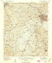 1949 Rock Hill1949 Print · USGSThe Piedmont of South Carolina appears here in the years following the war, showing a landscape of growing towns and deep-rooted rural communities. Genealogists can locate family landmarks such as the Rosenwald Sch, Freedom Cem, and McConnellsville along the Fishing Creek basin.3 unique versions available
End of results
Showing maps 1-4 of 4
Top cities near York
- Charlotte historical maps
- Rock Hill historical maps
- Gastonia historical maps
- Tega Cay historical maps
- Tega Cay historical maps
- Kings Mountain historical maps
See more
Top neighborhoods of York
- Forest Hills historical maps
- Wooded Valley historical maps
- English Gardens historical maps
- Musical Heights historical maps
- Pineview historical maps
- Poplar Acres historical maps
See more
Frequently asked questions
- What are the different types of historical maps available for York?
- What is the oldest map of York?
- Where can I purchase historical maps of York for my home or office?
- Where can I download high-res historical maps of York?
- Are there historical topographic maps available for York?
- Is there historical aerial imagery available for York?
- Where are historical maps of York sourced from?