1980s Maps of York, South Carolina
Explore 4 historic maps of York from the 1980s. These maps offer a rare glimpse into what life looked like during the 1980s — showing old roads, neighborhoods, homes, and landmarks that have changed or disappeared over time.
Whether you're researching your family's past, planning a metal detecting trip, or studying how York's landscape evolved across the 1980s, these high-resolution maps are a powerful tool for exploring the history of this region.
- Focus on a specific era: All maps on this page are from the 1980s, giving you a focused view of this time period.
- See what’s changed: Compare century-old streets, trails, and buildings to today's modern landscape using overlays and satellite layers.
- Research with precision: Use these maps for genealogy, historical research, land use analysis, or educational projects.
- View, download, or print: Maps are fully viewable online in high resolution, and can be downloaded or printed for your own records.
Start exploring York's history through authentic maps from the 1980s. This is your window into the past.
York, SC maps
(4)- 1982 Map of Tirzah, 1983 Print
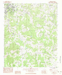 1982 Tirzah1983 Print · USGSThe York area of the South Carolina Piedmont is captured here during a period of steady rural growth in the early eighties. Genealogists and local historians can locate several family-named landmarks and old country parishes including Philadelphia Ch, Adnah Ch, and the crossroads at Guthries.
 - 1985 Map of Clover
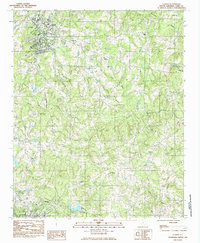 1985 Clover1985 Print · USGSClover and the surrounding York County countryside are captured here in the mid-eighties as a region of established crossroads and community churches. Genealogists can locate family landmarks such as Clover Chapel Cem and trace the rail paths of the Southern and Carolina and Northwestern.
 - 1986 Map of Spartanburg
 1986 Spartanburg1986 Print · USGSUpstate South Carolina is captured here in the mid-1980s, showcasing the region's transition from a textile-driven rail corridor to a modern interstate hub. Researchers can trace the legacy of the SOUTHERN railroad through mill towns like Glendale or explore the wooded reaches of the Sumter National Forest.2 unique versions available
 - 1986 Map of Gastonia
 1986 Gastonia1986 Print · USGSThe Carolina Piedmont in the mid-eighties shows a landscape shaped by Revolutionary War history and the textile industry. Trace the footprints of early battles at Kings Mountain National Military Park and locate depots along the Southern Railway in Shelby and Gastonia.
End of results
Showing maps 1-4 of 4
Top cities near York
- Charlotte historical maps
- Rock Hill historical maps
- Gastonia historical maps
- Tega Cay historical maps
- Tega Cay historical maps
- Kings Mountain historical maps
See more
Top neighborhoods of York
- Forest Hills historical maps
- Wooded Valley historical maps
- English Gardens historical maps
- Musical Heights historical maps
- Pineview historical maps
- Poplar Acres historical maps
See more
Frequently asked questions
- What are the different types of historical maps available for York?
- What is the oldest map of York?
- Where can I purchase historical maps of York for my home or office?
- Where can I download high-res historical maps of York?
- Are there historical topographic maps available for York?
- Is there historical aerial imagery available for York?
- Where are historical maps of York sourced from?