1970s Maps of Plankinton Township, South Dakota
Explore 2 historic maps of Plankinton Township from the 1970s. These maps offer a rare glimpse into what life looked like during the 1970s — showing old roads, neighborhoods, homes, and landmarks that have changed or disappeared over time.
Whether you're researching your family's past, planning a metal detecting trip, or studying how Plankinton Township's landscape evolved across the 1970s, these high-resolution maps are a powerful tool for exploring the history of this region.
- Focus on a specific era: All maps on this page are from the 1970s, giving you a focused view of this time period.
- See what’s changed: Compare century-old streets, trails, and buildings to today's modern landscape using overlays and satellite layers.
- Research with precision: Use these maps for genealogy, historical research, land use analysis, or educational projects.
- View, download, or print: Maps are fully viewable online in high resolution, and can be downloaded or printed for your own records.
Start exploring Plankinton Township's history through authentic maps from the 1970s. This is your window into the past.
Plankinton Township, SD maps
(2)- 1979 Map of Crystal Lake, 1980 Print
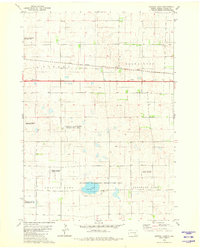 1979 Crystal Lake1980 Print · USGSAurora County's prairie wetlands and conservation areas are documented here during the late 1970s. Researchers can trace the path of the Chicago Milwaukee St Paul and Pacific railroad and locate landmarks like Crystal Lake and the Flowing Well.
 - 1979 Map of Storla SW, 1980 Print
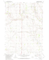 1979 Storla SW1980 Print · USGSAurora County’s rural prairie landscape is captured here in the late seventies, showing the transition of its township lands. Researchers can locate the local Townhall and trace the drainage of Firesteel Creek near the National Waterfowl Production Area.
End of results
Showing maps 1-2 of 2
Top cities near Plankinton Township
Top neighborhoods of Plankinton Township
Frequently asked questions
- What are the different types of historical maps available for Plankinton Township?
- What is the oldest map of Plankinton Township?
- Where can I purchase historical maps of Plankinton Township for my home or office?
- Where can I download high-res historical maps of Plankinton Township?
- Are there historical topographic maps available for Plankinton Township?
- Is there historical aerial imagery available for Plankinton Township?
- Where are historical maps of Plankinton Township sourced from?