1970s Maps of Truro Township, South Dakota
Explore 2 historic maps of Truro Township from the 1970s. These maps offer a rare glimpse into what life looked like during the 1970s — showing old roads, neighborhoods, homes, and landmarks that have changed or disappeared over time.
Whether you're researching your family's past, planning a metal detecting trip, or studying how Truro Township's landscape evolved across the 1970s, these high-resolution maps are a powerful tool for exploring the history of this region.
- Focus on a specific era: All maps on this page are from the 1970s, giving you a focused view of this time period.
- See what’s changed: Compare century-old streets, trails, and buildings to today's modern landscape using overlays and satellite layers.
- Research with precision: Use these maps for genealogy, historical research, land use analysis, or educational projects.
- View, download, or print: Maps are fully viewable online in high resolution, and can be downloaded or printed for your own records.
Start exploring Truro Township's history through authentic maps from the 1970s. This is your window into the past.
Truro Township, SD maps
(2)- 1979 Map of New Holland, 1980 Print
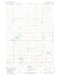 1979 New Holland1980 Print · USGSDouglas County farm country is captured here in the late seventies, showing the established communities of New Holland and Harrison. Researchers can trace local roots at Ebenezer Ch or locate the Markus Sch and Beukelman Sch schoolhouses.
 - 1979 Map of Aurora Center, 1980 Print
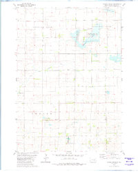 1979 Aurora Center1980 Print · USGSAurora County's prairie landscape in the late 1970s is defined by its vast public shooting areas and scattered wetlands. Researchers can locate the Quaker Cem, explore the shores of Crystal Lake, and trace the small community of Aurora Center.
End of results
Showing maps 1-2 of 2
Top cities near Truro Township
- Armour historical maps
- Corsica historical maps
- Plankinton historical maps
- White Lake historical maps
- Stickney historical maps
- Joubert historical maps
Frequently asked questions
- What are the different types of historical maps available for Truro Township?
- What is the oldest map of Truro Township?
- Where can I purchase historical maps of Truro Township for my home or office?
- Where can I download high-res historical maps of Truro Township?
- Are there historical topographic maps available for Truro Township?
- Is there historical aerial imagery available for Truro Township?
- Where are historical maps of Truro Township sourced from?