1970s Maps of Geddes, South Dakota
Explore 2 historic maps of Geddes from the 1970s. These maps offer a rare glimpse into what life looked like during the 1970s — showing old roads, neighborhoods, homes, and landmarks that have changed or disappeared over time.
Whether you're researching your family's past, planning a metal detecting trip, or studying how Geddes's landscape evolved across the 1970s, these high-resolution maps are a powerful tool for exploring the history of this region.
- Focus on a specific era: All maps on this page are from the 1970s, giving you a focused view of this time period.
- See what’s changed: Compare century-old streets, trails, and buildings to today's modern landscape using overlays and satellite layers.
- Research with precision: Use these maps for genealogy, historical research, land use analysis, or educational projects.
- View, download, or print: Maps are fully viewable online in high resolution, and can be downloaded or printed for your own records.
Start exploring Geddes's history through authentic maps from the 1970s. This is your window into the past.
Geddes, SD maps
(2)- 1977 Map of Lake Andes NW, 1979 Print
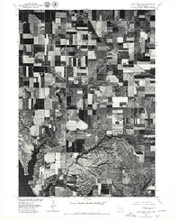 1977 Lake Andes NW1979 Print · USGSThe prairie landscape of Charles Mix County is captured in the late seventies, showing the transition from grid-patterned fields to the river bluffs. Genealogists and land researchers can trace the area around Geddes and the extensive shoreline of Lake Francis Case.
 - 1979 Map of Geddes, 1980 Print
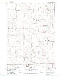 1979 Geddes1980 Print · USGSGeddes and the surrounding townships of Charles Mix County are documented here during the late seventies, showing a landscape defined by prairie rail lines and waterfowl conservation. You can trace the path of the Chicago Milwaukee St Paul and Pacific railroad or locate the Morningside Cem and Pease Creek.
End of results
Showing maps 1-2 of 2
Top cities near Geddes
- Platte historical maps
- Lake Andes historical maps
- Pickstown historical maps
- Joubert historical maps
- Fairfax historical maps
Frequently asked questions
- What are the different types of historical maps available for Geddes?
- What is the oldest map of Geddes?
- Where can I purchase historical maps of Geddes for my home or office?
- Where can I download high-res historical maps of Geddes?
- Are there historical topographic maps available for Geddes?
- Is there historical aerial imagery available for Geddes?
- Where are historical maps of Geddes sourced from?