1960s Maps of Signal Township, South Dakota
Explore 2 historic maps of Signal Township from the 1960s. These maps offer a rare glimpse into what life looked like during the 1960s — showing old roads, neighborhoods, homes, and landmarks that have changed or disappeared over time.
Whether you're researching your family's past, planning a metal detecting trip, or studying how Signal Township's landscape evolved across the 1960s, these high-resolution maps are a powerful tool for exploring the history of this region.
- Focus on a specific era: All maps on this page are from the 1960s, giving you a focused view of this time period.
- See what’s changed: Compare century-old streets, trails, and buildings to today's modern landscape using overlays and satellite layers.
- Research with precision: Use these maps for genealogy, historical research, land use analysis, or educational projects.
- View, download, or print: Maps are fully viewable online in high resolution, and can be downloaded or printed for your own records.
Start exploring Signal Township's history through authentic maps from the 1960s. This is your window into the past.
Signal Township, SD maps
(2)- 1964 Map of Campbell Creek, 1965 Print
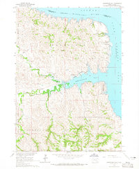
 1964 Campbell Creek1965 Print · USGSThe Missouri River valley in the early 1960s shows a landscape reshaped by the Missouri River Basin development program and the creation of the Fort Randall reservoir. Genealogists and local historians can trace legacy land divisions along the Fort Randall Military Reservation Boundary and find early recreation sites like Pease Creek Recreation Area.
 - 1964 Map of Whetstone Bay, 1965 Print
 1964 Whetstone Bay1965 Print · USGSThe Missouri River breaks of Gregory County are captured here in the mid-1960s following the creation of the Fort Randall Reservoir. Researchers can trace the Rosebud Indian Reservation Boundary and locate landmarks like Mulehead Ranch and the Whetstone Bay Recreation Area.
End of results
Showing maps 1-2 of 2
Top cities near Signal Township
- Platte historical maps
- Bonesteel historical maps
- Geddes historical maps
- Joubert historical maps
- Fairfax historical maps
Frequently asked questions
- What are the different types of historical maps available for Signal Township?
- What is the oldest map of Signal Township?
- Where can I purchase historical maps of Signal Township for my home or office?
- Where can I download high-res historical maps of Signal Township?
- Are there historical topographic maps available for Signal Township?
- Is there historical aerial imagery available for Signal Township?
- Where are historical maps of Signal Township sourced from?