1970s Maps of Clark, South Dakota
Explore 3 historic maps of Clark from the 1970s. These maps offer a rare glimpse into what life looked like during the 1970s — showing old roads, neighborhoods, homes, and landmarks that have changed or disappeared over time.
Whether you're researching your family's past, planning a metal detecting trip, or studying how Clark's landscape evolved across the 1970s, these high-resolution maps are a powerful tool for exploring the history of this region.
- Focus on a specific era: All maps on this page are from the 1970s, giving you a focused view of this time period.
- See what’s changed: Compare century-old streets, trails, and buildings to today's modern landscape using overlays and satellite layers.
- Research with precision: Use these maps for genealogy, historical research, land use analysis, or educational projects.
- View, download, or print: Maps are fully viewable online in high resolution, and can be downloaded or printed for your own records.
Start exploring Clark's history through authentic maps from the 1970s. This is your window into the past.
Clark, SD maps
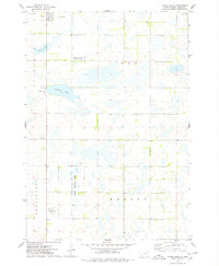
(3)- 1973 Map of Baileys Lake, 1978 Print
 1973 Baileys Lake1978 Print · USGSThe prairie wetlands of Clark County are captured here in the early seventies, showing a landscape of scattered farmsteads and rural townships. Genealogists and local historians can locate Clark Center Ch, the small community of Baily, and the Cem.
 - 1973 Map of Clark South, 1978 Print
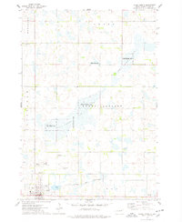
 1973 Clark South1978 Print · USGSThe town of Clark and the surrounding South Dakota prairie wetlands are captured here in the early seventies. Genealogists and local historians can trace section lines across Lincoln and Day townships or locate rural landmarks like the Townhall and Antelope Lake.
 - 1973 Map of Clark North, 1978 Print
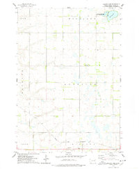
 1973 Clark North1978 Print · USGSThe eastern South Dakota prairie comes into focus in the early 1970s, centered on the wetlands and hunting grounds of Clark County. Researchers can trace local lineage and land use through Rose Hill Cemetery, the Chicago and North Western rail corridor, and the County Fairground.
End of results
Showing maps 1-3 of 3
Top cities near Clark
- Bradley historical maps
- Elrod historical maps
- Raymond historical maps
- Vienna historical maps
- Garden City historical maps
- Naples historical maps
Frequently asked questions
- What are the different types of historical maps available for Clark?
- What is the oldest map of Clark?
- Where can I purchase historical maps of Clark for my home or office?
- Where can I download high-res historical maps of Clark?
- Are there historical topographic maps available for Clark?
- Is there historical aerial imagery available for Clark?
- Where are historical maps of Clark sourced from?