1970s Maps of Valley Township, South Dakota
Explore 3 historic maps of Valley Township from the 1970s. These maps offer a rare glimpse into what life looked like during the 1970s — showing old roads, neighborhoods, homes, and landmarks that have changed or disappeared over time.
Whether you're researching your family's past, planning a metal detecting trip, or studying how Valley Township's landscape evolved across the 1970s, these high-resolution maps are a powerful tool for exploring the history of this region.
- Focus on a specific era: All maps on this page are from the 1970s, giving you a focused view of this time period.
- See what’s changed: Compare century-old streets, trails, and buildings to today's modern landscape using overlays and satellite layers.
- Research with precision: Use these maps for genealogy, historical research, land use analysis, or educational projects.
- View, download, or print: Maps are fully viewable online in high resolution, and can be downloaded or printed for your own records.
Start exploring Valley Township's history through authentic maps from the 1970s. This is your window into the past.
Valley Township, SD maps
(3)- 1979 Map of Delmont, 1980 Print
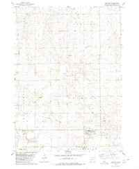 1979 Delmont1980 Print · USGSDelmont and its surrounding townships are shown here in the late 1970s, as the local landscape remained deeply rooted in its agricultural and rail-era foundations. Researchers can trace the Old Railroad Grade and locate several rural burial sites, including Old Missouri Cem and Neusatz Cem.
 - 1979 Map of Armour, 1980 Print
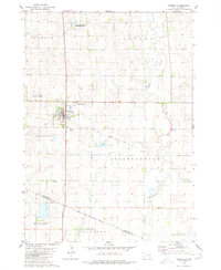 1979 Armour1980 Print · USGSDouglas County farming and conservation efforts take center stage in this late-seventies survey of the Armour region. Local researchers can trace the Old Railroad Grade and locate burials at Pleasant Ridge Cem or the Yankton Indian Reservation Boundary.
 - 1979 Map of Hillside, 1980 Print
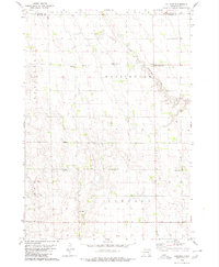 1979 Hillside1980 Print · USGSDouglas and Davison Counties are shown here during the late 1970s, a period when rural schoolhouses and country churches still anchored the South Dakota prairie. Genealogists and local historians can trace family ties at Friedhof Cem, Roberts Chapel Cem, or near the settlement of Hillside.
End of results
Showing maps 1-3 of 3
Top cities near Valley Township
Frequently asked questions
- What are the different types of historical maps available for Valley Township?
- What is the oldest map of Valley Township?
- Where can I purchase historical maps of Valley Township for my home or office?
- Where can I download high-res historical maps of Valley Township?
- Are there historical topographic maps available for Valley Township?
- Is there historical aerial imagery available for Valley Township?
- Where are historical maps of Valley Township sourced from?