1970s Maps of Hanson County, South Dakota
Explore 8 historic maps of Hanson County from the 1970s. These maps offer a rare glimpse into what life looked like during the 1970s — showing old roads, neighborhoods, homes, and landmarks that have changed or disappeared over time.
Whether you're researching your family's past, planning a metal detecting trip, or studying how Hanson County's landscape evolved across the 1970s, these high-resolution maps are a powerful tool for exploring the history of this region.
- Focus on a specific era: All maps on this page are from the 1970s, giving you a focused view of this time period.
- See what’s changed: Compare century-old streets, trails, and buildings to today's modern landscape using overlays and satellite layers.
- Research with precision: Use these maps for genealogy, historical research, land use analysis, or educational projects.
- View, download, or print: Maps are fully viewable online in high resolution, and can be downloaded or printed for your own records.
Start exploring Hanson County's history through authentic maps from the 1970s. This is your window into the past.
Hanson County, SD maps
(8)- 1970 Map of Clayton NE, 1972 Print
 1970 Clayton NE1972 Print · USGSHutchinson County agriculture and community life are well-documented in the early seventies, featuring the rolling prairie around Wolf Creek. Genealogists can trace local roots through landmarks like Stern Cem, New Hutterthal Ch, and the shores of Silver Lake.
 - 1973 Map of Spencer SW, 1978 Print
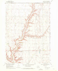
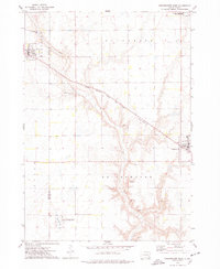
 1973 Spencer SW1978 Print · USGSHanson County is captured here in the early 1970s, focused on the rail-side community of Emery and the surrounding townships. Researchers can trace family history through several local burial sites like St Martins Cem and Elfert Cem or follow the path of the Chicago Milwaukee St Paul and Pacific railroad.
 - 1973 Map of Ness Chain Lakes, 1978 Print
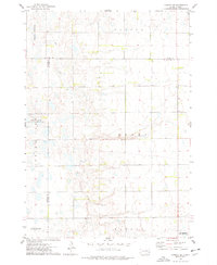
 1973 Ness Chain Lakes1978 Print · USGSThe tri-county borderlands of Sanborn, Miner, and Hanson counties are documented in the 1970s, showcasing a landscape of prairie potholes and wetlands. Researchers can trace the rural layout of Fairview and find local landmarks like Redstone Cem and Lake Leo.
 - 1973 Map of Farmer, 1978 Print
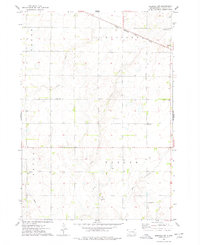
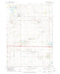
 1973 Farmer1978 Print · USGSHanson County in the mid-1970s is shown here as a landscape of structured townships and dual rail lines. Genealogists and local historians can locate the community of Farmer, trace the Chicago and North Western railroad, and find St Peter Cem.
 - 1973 Map of Bridgewater West, 1978 Print
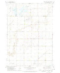
 1973 Bridgewater West1978 Print · USGSThis South Dakota prairie landscape in the 1970s reveals the intersection of the railroad and rural life along the Hanson and McCook County line. Researchers can locate family sites like Rasmussen Cem or trace the path of the Chicago Milwaukee St Paul and Pacific railroad.
 - 1973 Map of Canova SE, 1978 Print
 1973 Canova SE1978 Print · USGSEastern South Dakota in the 1970s shows a landscape of highly structured prairie farming and conservation efforts. Genealogists and local historians can locate early landmarks like Edgerton, Immanuel Ch, and Pleasant Hill Cem.
 - 1973 Map of Spencer, 1978 Print
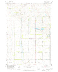
 1973 Spencer1978 Print · USGSSpencer and the surrounding prairie townships are captured here in the early 1970s, showcasing a landscape of rail-fed commerce and extensive waterfowl conservation. Researchers can locate family landmarks like Lakeside Cem, the local QUARRY, and the Chicago and North Western rail corridor.
 - 1973 Map of Epiphany, 1978 Print
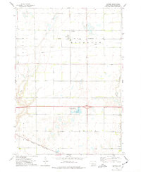
 1973 Epiphany1978 Print · USGSThe border of Miner and Hanson Counties comes into focus in the 1970s, revealing a landscape of prairie wetlands and rural townships. Genealogists and outdoorsmen can trace land around Epiphany or explore the boundaries of the Long Lake State Public Shooting Area and Spring Lake.
End of results
Showing maps 1-8 of 8
Top cities of Hanson County
Frequently asked questions
- What are the different types of historical maps available for Hanson County?
- What is the oldest map of Hanson County?
- Where can I purchase historical maps of Hanson County for my home or office?
- Where can I download high-res historical maps of Hanson County?
- Are there historical topographic maps available for Hanson County?
- Is there historical aerial imagery available for Hanson County?
- Where are historical maps of Hanson County sourced from?