1960s Maps of Highland Township, South Dakota
Explore 4 historic maps of Highland Township from the 1960s. These maps offer a rare glimpse into what life looked like during the 1960s — showing old roads, neighborhoods, homes, and landmarks that have changed or disappeared over time.
Whether you're researching your family's past, planning a metal detecting trip, or studying how Highland Township's landscape evolved across the 1960s, these high-resolution maps are a powerful tool for exploring the history of this region.
- Focus on a specific era: All maps on this page are from the 1960s, giving you a focused view of this time period.
- See what’s changed: Compare century-old streets, trails, and buildings to today's modern landscape using overlays and satellite layers.
- Research with precision: Use these maps for genealogy, historical research, land use analysis, or educational projects.
- View, download, or print: Maps are fully viewable online in high resolution, and can be downloaded or printed for your own records.
Start exploring Highland Township's history through authentic maps from the 1960s. This is your window into the past.
Highland Township, SD maps
(4)- 1962 Map of Canton, 1964 Print
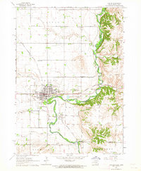 1962 Canton1964 Print · USGSThe South Dakota and Iowa border comes alive in the early sixties as the Big Sioux River winds past bustling prairie towns. Genealogists can locate several rural schools and cemeteries, including Augustana Academy, Beloit Cem, and York Sch.2 unique versions available
 - 1964 Map of Canton SW, 1965 Print
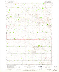 1964 Canton SW1965 Print · USGSLincoln County townships such as Lynn and Dayton are shown here in the mid-1960s, still defined by a dense network of country schools and rail lines. Genealogists can locate family landmarks like Grand Valley Church, Forest Hill Cemetery, and Kerley School.
 - 1968 Map of Alcester NW, 1970 Print
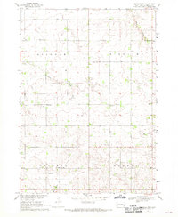 1968 Alcester NW1970 Print · USGSLincoln County farmland in the late sixties is defined by its dense network of rural schools and country churches. Genealogists can trace family footprints near the Tuntland Cem, Norway Center, and several local landmarks like Sundy Sch.2 unique versions available
 - 1968 Map of Alcester NE, 1970 Print
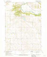 1968 Alcester NE1970 Print · USGSThe Big Sioux River valley comes to life in the late sixties as it winds through Lincoln County. Genealogists can trace early rural life through family-named landmarks like Moe Sch, Bethany Cem, and the tracks of the Chicago Milwaukee St Paul and Pacific railroad.2 unique versions available
End of results
Showing maps 1-4 of 4
Top cities near Highland Township
- Harrisburg historical maps
- Canton historical maps
- Hawarden historical maps
- Beresford historical maps
- Inwood historical maps
- Worthing historical maps
See more
Frequently asked questions
- What are the different types of historical maps available for Highland Township?
- What is the oldest map of Highland Township?
- Where can I purchase historical maps of Highland Township for my home or office?
- Where can I download high-res historical maps of Highland Township?
- Are there historical topographic maps available for Highland Township?
- Is there historical aerial imagery available for Highland Township?
- Where are historical maps of Highland Township sourced from?