
1962 Map of Canton
USGS Topo · Published 1964About this map
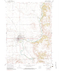
The Big Sioux River carves a winding path along the South Dakota and Iowa border, defining the geography of this prairie landscape. The city of Canton serves as the regional hub, notable for the presence of the Augustana Academy and the Canton-Inwood Hospital. To the south, the smaller settlement of Beloit sits at a sharp bend in the river, served by the Chicago Milwaukee St Paul and Pacific railroad which cuts diagonally across the township lines. The survey reveals a dense network of rural education, featuring one-room schoolhouses like York Sch, Banner Sch, and Sunnyside Sch distributed across the townships of Dayton and Canton. The transition from the flat agricultural uplands to the river's floodplain is marked by the Centennial Valley and numerous Gravel Pits that suggest the area's local industrial activity during the early 1960s.
Find a feature on this map
32 named features on this map. Tap any name to fly to it.
Don’t see what you’re looking for? This feature index may not catch every label — zoom into the map to look around manually.
Map Details
Editions of this 1962 Canton Map
2 editions found
Other maps of this area

1897 · Canton
USGS Topo · 1:125,000

1900 · Canton
USGS Topo · 1:125,000

1955 · Sioux Falls
USGS Topo · 1:250,000

1958 · Sioux Falls
USGS Topo · 1:250,000

1962 · Klondike
USGS Topo · 1:24,000

1962 · Harrisburg
USGS Topo · 1:24,000

1964 · Canton SW
USGS Topo · 1:24,000

1968 · Alcester NW
USGS Topo · 1:24,000

1968 · Alcester NE
USGS Topo · 1:24,000

1968 · Fairview
USGS Topo · 1:24,000