1960s Maps of Miner County, South Dakota
Explore 4 historic maps of Miner County from the 1960s. These maps offer a rare glimpse into what life looked like during the 1960s — showing old roads, neighborhoods, homes, and landmarks that have changed or disappeared over time.
Whether you're researching your family's past, planning a metal detecting trip, or studying how Miner County's landscape evolved across the 1960s, these high-resolution maps are a powerful tool for exploring the history of this region.
- Focus on a specific era: All maps on this page are from the 1960s, giving you a focused view of this time period.
- See what’s changed: Compare century-old streets, trails, and buildings to today's modern landscape using overlays and satellite layers.
- Research with precision: Use these maps for genealogy, historical research, land use analysis, or educational projects.
- View, download, or print: Maps are fully viewable online in high resolution, and can be downloaded or printed for your own records.
Start exploring Miner County's history through authentic maps from the 1960s. This is your window into the past.
Miner County, SD maps
(4)- 1968 Map of Oldham SW, 1970 Print
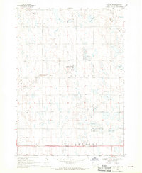 1968 Oldham SW1970 Print · USGSMiner County townships show a landscape of prairie potholes and productive farmland in the late 1960s. Trace local landmarks like the Belleview Ch, the Townhall, and the winding East Fork Vermillion River.
 - 1968 Map of Oldham NW, 1970 Print
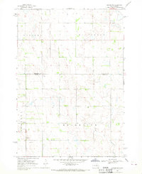 1968 Oldham NW1970 Print · USGSIn the late 1960s, the rural borderlands of Kingsbury and Miner Counties maintained a quiet, agricultural character. Genealogists and local historians can locate the Berton Cem and trace the winding course of the East Fork Vermillion River.
 - 1968 Map of Oldham, 1970 Print
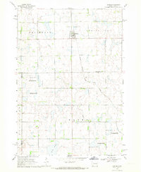 1968 Oldham1970 Print · USGSKingsbury County and the town of Oldham are shown during the late 1960s, capturing a traditional South Dakota prairie community linked by rail. Researchers can trace family sites at St Andreas Cem or Toles Cem and locate landmarks like the Townhall.
 - 1968 Map of Oldham SE, 1970 Print
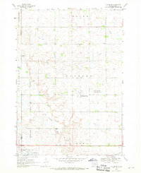 1968 Oldham SE1970 Print · USGSLake County prairie life in the late sixties is centered on the railroad town of Winifred and its surrounding wetlands. Genealogists and local historians can trace family locations near St Johns Ch, the Winfred Cem, and the winding East Fork Vermillion River.
End of results
Showing maps 1-4 of 4
Frequently asked questions
- What are the different types of historical maps available for Miner County?
- What is the oldest map of Miner County?
- Where can I purchase historical maps of Miner County for my home or office?
- Where can I download high-res historical maps of Miner County?
- Are there historical topographic maps available for Miner County?
- Is there historical aerial imagery available for Miner County?
- Where are historical maps of Miner County sourced from?