1970s Maps of Grafton Township, South Dakota
Explore 2 historic maps of Grafton Township from the 1970s. These maps offer a rare glimpse into what life looked like during the 1970s — showing old roads, neighborhoods, homes, and landmarks that have changed or disappeared over time.
Whether you're researching your family's past, planning a metal detecting trip, or studying how Grafton Township's landscape evolved across the 1970s, these high-resolution maps are a powerful tool for exploring the history of this region.
- Focus on a specific era: All maps on this page are from the 1970s, giving you a focused view of this time period.
- See what’s changed: Compare century-old streets, trails, and buildings to today's modern landscape using overlays and satellite layers.
- Research with precision: Use these maps for genealogy, historical research, land use analysis, or educational projects.
- View, download, or print: Maps are fully viewable online in high resolution, and can be downloaded or printed for your own records.
Start exploring Grafton Township's history through authentic maps from the 1970s. This is your window into the past.
Grafton Township, SD maps
(2)- 1971 Map of Howard NE, 1973 Print
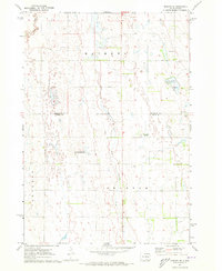 1971 Howard NE1973 Print · USGSMiner County farming and communal life are documented here in the early 1970s. Researchers can trace the Cloverleaf Colony, explore the West Fork Vermillion River valley, and locate Gravel Pits across the prairie.
 - 1971 Map of Howard, 1973 Print
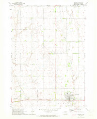 1971 Howard1973 Print · USGSMiner County, South Dakota, is captured here in the early seventies, showcasing a landscape of prairie townships and rail-connected towns. Genealogists and historians can locate St. Johns Cemetery, trace the Chicago and North Western tracks through Vilas, or explore the streets of Howard.
End of results
Showing maps 1-2 of 2
Top cities near Grafton Township
- Howard historical maps
- Lake Preston historical maps
- Winfred historical maps
- Carthage historical maps
- Esmond historical maps
- Roswell historical maps
See more
Top neighborhoods of Grafton Township
Frequently asked questions
- What are the different types of historical maps available for Grafton Township?
- What is the oldest map of Grafton Township?
- Where can I purchase historical maps of Grafton Township for my home or office?
- Where can I download high-res historical maps of Grafton Township?
- Are there historical topographic maps available for Grafton Township?
- Is there historical aerial imagery available for Grafton Township?
- Where are historical maps of Grafton Township sourced from?