1970s Maps of Moody County, South Dakota
Explore 4 historic maps of Moody County from the 1970s. These maps offer a rare glimpse into what life looked like during the 1970s — showing old roads, neighborhoods, homes, and landmarks that have changed or disappeared over time.
Whether you're researching your family's past, planning a metal detecting trip, or studying how Moody County's landscape evolved across the 1970s, these high-resolution maps are a powerful tool for exploring the history of this region.
- Focus on a specific era: All maps on this page are from the 1970s, giving you a focused view of this time period.
- See what’s changed: Compare century-old streets, trails, and buildings to today's modern landscape using overlays and satellite layers.
- Research with precision: Use these maps for genealogy, historical research, land use analysis, or educational projects.
- View, download, or print: Maps are fully viewable online in high resolution, and can be downloaded or printed for your own records.
Start exploring Moody County's history through authentic maps from the 1970s. This is your window into the past.
Moody County, SD maps
(4)- 1972 Map of Flandreau NE, 1973 Print
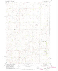 1972 Flandreau NE1973 Print · USGSThe rural townships of eastern South Dakota are captured here in the early seventies as the agricultural landscape matured. Genealogists and historians can locate the local Townhall, trace the Chicago and North Western rail line, and find old Gravel Pits.
 - 1972 Map of Dell Rapids NE, 1973 Print
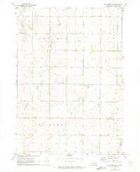 1972 Dell Rapids NE1973 Print · USGSMoody County in the early seventies reveals a landscape of deep-rooted prairie settlements and family-run townships. Genealogists and local historians can trace legacy sites like the Swedish Augustana Cem, Oslo Cem, and Trinity Ch along the waters of Brookfield Creek.
 - 1972 Map of Dell Rapids SE, 1973 Print
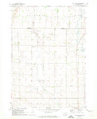 1972 Dell Rapids SE1973 Print · USGSThe rural border between Moody and Minnehaha Counties comes into focus during the early 1970s, showcasing a landscape of prairie townships and creek valleys. Researchers can locate burial sites like Reformed Church Cem and trace the paths of Pipestone Creek and West Pipestone Creek.2 unique versions available
 - 1972 Map of Flandreau, 1973 Print
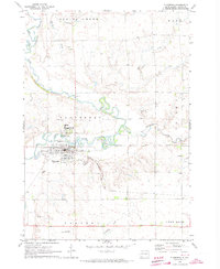 1972 Flandreau1973 Print · USGSMoody County in the early seventies centers on the meanders of the Big Sioux River and the bustling rail hub at Flandreau. Family historians can locate specific sites like the Flandreau Indian Sch, Catholic Cem, and the old Chicago Milwaukee St Paul and Pacific rail line.
End of results
Showing maps 1-4 of 4
Top cities of Moody County
Frequently asked questions
- What are the different types of historical maps available for Moody County?
- What is the oldest map of Moody County?
- Where can I purchase historical maps of Moody County for my home or office?
- Where can I download high-res historical maps of Moody County?
- Are there historical topographic maps available for Moody County?
- Is there historical aerial imagery available for Moody County?
- Where are historical maps of Moody County sourced from?