1960s Maps of Fremont Township, South Dakota
Explore 4 historic maps of Fremont Township from the 1960s. These maps offer a rare glimpse into what life looked like during the 1960s — showing old roads, neighborhoods, homes, and landmarks that have changed or disappeared over time.
Whether you're researching your family's past, planning a metal detecting trip, or studying how Fremont Township's landscape evolved across the 1960s, these high-resolution maps are a powerful tool for exploring the history of this region.
- Focus on a specific era: All maps on this page are from the 1960s, giving you a focused view of this time period.
- See what’s changed: Compare century-old streets, trails, and buildings to today's modern landscape using overlays and satellite layers.
- Research with precision: Use these maps for genealogy, historical research, land use analysis, or educational projects.
- View, download, or print: Maps are fully viewable online in high resolution, and can be downloaded or printed for your own records.
Start exploring Fremont Township's history through authentic maps from the 1960s. This is your window into the past.
Fremont Township, SD maps
(4)- 1964 Map of Medary, 1965 Print
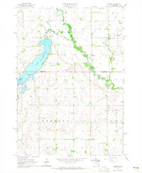 1964 Medary1965 Print · USGSThe Brookings and Moody County borderlands are seen here in the mid-1960s, centered on the river-cut prairies of eastern South Dakota. Genealogists and researchers can locate several rural schools and landmarks like Lake Campbell Cem, Galla Sch, and the historic settlement of Medary.4 unique versions available
 - 1964 Map of Rutland SE, 1965 Print
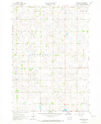 1964 Rutland SE1965 Print · USGSPrairie townships in Moody County are shown in detail during the 1960s, capturing a rural landscape of family farms and section roads. Researchers can locate community landmarks like Whaley Sch, Mt Auburn Cem, and the Wellman Ch.2 unique versions available
 - 1968 Map of Rutland, 1971 Print
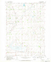 1968 Rutland1971 Print · USGSThe prairie townships of Lake County were dominated by the rail-and-water landscape of the late sixties. Researchers can trace the Great Northern line through Rutland, locate the Lake Park Cem, and map the shores of Milwaukee Lake.
 - 1968 Map of Rutland NW, 1971 Print
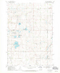 1968 Rutland NW1971 Print · USGSEastern South Dakota’s agricultural and wetland landscape is captured here in the late sixties, where the border of Lake and Brookings Counties meets. Genealogists can locate family landmarks such as Oslo Ch, Prairie Queen Cem, and the Townhall.2 unique versions available
End of results
Showing maps 1-4 of 4
Top cities near Fremont Township
- Brookings historical maps
- Flandreau historical maps
- Volga historical maps
- Medary historical maps
- Colman historical maps
- Aurora historical maps
See more
Frequently asked questions
- What are the different types of historical maps available for Fremont Township?
- What is the oldest map of Fremont Township?
- Where can I purchase historical maps of Fremont Township for my home or office?
- Where can I download high-res historical maps of Fremont Township?
- Are there historical topographic maps available for Fremont Township?
- Is there historical aerial imagery available for Fremont Township?
- Where are historical maps of Fremont Township sourced from?