1960s Maps of Lone Rock Township, South Dakota
Explore 2 historic maps of Lone Rock Township from the 1960s. These maps offer a rare glimpse into what life looked like during the 1960s — showing old roads, neighborhoods, homes, and landmarks that have changed or disappeared over time.
Whether you're researching your family's past, planning a metal detecting trip, or studying how Lone Rock Township's landscape evolved across the 1960s, these high-resolution maps are a powerful tool for exploring the history of this region.
- Focus on a specific era: All maps on this page are from the 1960s, giving you a focused view of this time period.
- See what’s changed: Compare century-old streets, trails, and buildings to today's modern landscape using overlays and satellite layers.
- Research with precision: Use these maps for genealogy, historical research, land use analysis, or educational projects.
- View, download, or print: Maps are fully viewable online in high resolution, and can be downloaded or printed for your own records.
Start exploring Lone Rock Township's history through authentic maps from the 1960s. This is your window into the past.
Lone Rock Township, SD maps
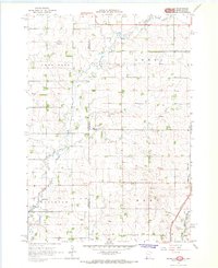
(2)- 1967 Map of Elkton SW, 1968 Print
 1967 Elkton SW1968 Print · USGSThe Minnesota and South Dakota borderlands come alive in this mid-sixties survey of Pipestone and Moody Counties. Researchers can trace the path of the Milwaukee Road through Airlie or locate the rural Fletcher Sch.2 unique versions available
 - 1967 Map of Jasper NW, 1968 Print
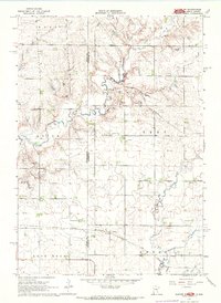
 1967 Jasper NW1968 Print · USGSThe borderlands of Minnesota and South Dakota are captured here in the late sixties, showing a landscape of family farms and rural townships. Researchers can trace local history at Lone Rock Ch, Eden Cem, and the old Townhall near Pipestone Creek.2 unique versions available
End of results
Showing maps 1-2 of 2
Top cities near Lone Rock Township
- Pipestone historical maps
- Dell Rapids historical maps
- Flandreau historical maps
- Jasper historical maps
- Egan historical maps
- Trent historical maps
See more
Frequently asked questions
- What are the different types of historical maps available for Lone Rock Township?
- What is the oldest map of Lone Rock Township?
- Where can I purchase historical maps of Lone Rock Township for my home or office?
- Where can I download high-res historical maps of Lone Rock Township?
- Are there historical topographic maps available for Lone Rock Township?
- Is there historical aerial imagery available for Lone Rock Township?
- Where are historical maps of Lone Rock Township sourced from?