Old Maps of McGee, South Dakota for Metal Detecting
Plan your next treasure hunt with 10 historic maps of McGee. Find old homesites, ghost towns, trails, and gathering spots that may be lost to time — perfect for identifying promising metal detecting locations.
- Locate forgotten sites: Uncover places like long-lost settlements, abandoned rail lines, or gathering spots.
- Plan better hunts: Use map overlays combined with LiDAR or satellite views to narrow in on historically rich areas.
- Made for detectorists: Thousands of hobbyists use these maps to discover relics, coins, and hidden history.
Use these historic maps to boost your research and find new opportunities beneath the surface of McGee.
McGee, SD maps
(10)- 1893 Map of Rapid
 1893 Rapid1893 Print · USGSThe Black Hills frontier comes alive in the late nineteenth century as rail lines and military outposts shape the territory. Genealogists and researchers can trace the early layout of Rapid, locate Fort Meade, and find family-named landmarks like Doe Dotie Ranch or Piedmont.2 unique versions available
 - 1898 Map of Rapid
 1898 Rapid1898 Print · USGSThe Black Hills foothills come alive in the 1890s, where early railroads meet military outposts and pioneer settlements. Trace the early streets of Rapid City, the grounds of Fort Meade, and localized landmarks like Crystal Cave.2 unique versions available
 - 1903 Map of Rapid
 1903 Rapid1903 Print · USGSThe Black Hills transition from mountains to plains at the turn of the century, centered on the growing rail hub of Rapid. Researchers can trace the early rail corridor of the Fremont Elkhorn and Missouri Valley through Fort Meade and Piedmont.4 unique versions available
 - 1953 Map of Rapid City, 1964 Print
 1953 Rapid City1964 Print · USGSWestern South Dakota's transition from the Black Hills to the open prairie is captured here during the mid-fifties. Researchers can trace the development of Ellsworth Air Force Base alongside historic landmarks like Bear Butte and the Lower Alkali School.3 unique versions available
 - 1954 Map of Pactola Dam, 1955 Print
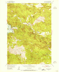 1954 Pactola Dam1955 Print · USGSThe Black Hills landscape undergoes a major transformation in the mid-1950s as the Pactola Reservoir takes shape. Genealogists and historians can locate early mountain camps like Placerville Camp and Hisega, or trace the path of the Abandoned Flume along Rapid Creek.6 unique versions available
 - 1957 Map of Rapid City
 1957 Rapid City1957 Print · USGSWestern South Dakota in the mid-fifties reveals a landscape of high-altitude forests and growing military installations. Researchers can trace the development of Ellsworth Air Force Base, locate the Theodore Roosevelt Monument, and find rural landmarks like Lower Alkali School.
 - 2012 Map of Pactola Dam, 2012 Print
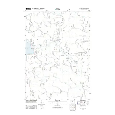 2012 Pactola Dam2012 Print · USGSCovers McGee, including Hisega, Big Bend, and other nearby areas
 - 2015 Map of Pactola Dam, 2015 Print
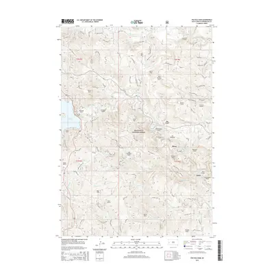 2015 Pactola Dam2015 Print · USGSCovers McGee, including Hisega, Big Bend, and other nearby areas
 - 2017 Map of Pactola Dam, 2017 Print
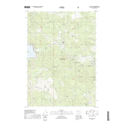 2017 Pactola Dam2017 Print · USGSCovers McGee, including Hisega, Big Bend, and other nearby areas
 - 2021 Map of Pactola Dam, 2021 Print
 2021 Pactola Dam2021 Print · USGSPennington County’s mountain interior is shown in great detail during the early 2020s, centered on the critical water systems of the Black Hills National Forest. Researchers can trace the development of local communities like Johnson Siding and Hisega, or locate landmarks such as the Thunderhead Falls Tunnel.
End of results
Showing maps 1-10 of 10
Top cities near McGee
- Rapid City historical maps
- Summerset historical maps
- Hill City historical maps
- Hermosa historical maps
- Keystone historical maps
Frequently asked questions
- What are the different types of historical maps available for McGee?
- What is the oldest map of McGee?
- Where can I purchase historical maps of McGee for my home or office?
- Where can I download high-res historical maps of McGee?
- Are there historical topographic maps available for McGee?
- Is there historical aerial imagery available for McGee?
- Where are historical maps of McGee sourced from?