1970s Maps of Diamond, Lake Traverse District
Explore 2 historic maps of Diamond from the 1970s. These maps offer a rare glimpse into what life looked like during the 1970s — showing old roads, neighborhoods, homes, and landmarks that have changed or disappeared over time.
Whether you're researching your family's past, planning a metal detecting trip, or studying how Diamond's landscape evolved across the 1970s, these high-resolution maps are a powerful tool for exploring the history of this region.
- Focus on a specific era: All maps on this page are from the 1970s, giving you a focused view of this time period.
- See what’s changed: Compare century-old streets, trails, and buildings to today's modern landscape using overlays and satellite layers.
- Research with precision: Use these maps for genealogy, historical research, land use analysis, or educational projects.
- View, download, or print: Maps are fully viewable online in high resolution, and can be downloaded or printed for your own records.
Start exploring Diamond's history through authentic maps from the 1970s. This is your window into the past.
Diamond, Lake Traverse District maps
(2)- 1972 Map of Beardsley NW, 1974 Print
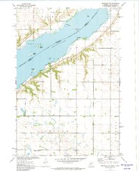 1972 Beardsley NW1974 Print · USGSThe Minnesota-South Dakota borderlands come into focus in the early seventies, centered on the broad waters of Lake Traverse. Genealogists and historians can locate the Lake View Cem and small rural hubs like Dakomin and Layden.
 - 1977 Map of Beardsley NW, 1979 Print
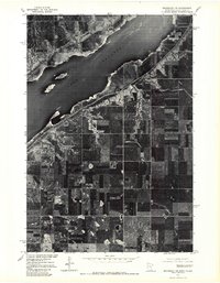 1977 Beardsley NW1979 Print · USGSThe Minnesota-South Dakota borderlands appear in striking detail in the late seventies, showing the agricultural plains above Lake Traverse. Researchers can trace the lakeside settlement at Dakomin and the precise layout of farmsteads and field patterns across this border region.
End of results
Showing maps 1-2 of 2
Top cities near Diamond
- Wheaton historical maps
- Browns Valley historical maps
- Rosholt historical maps
- Beardsley historical maps
- New Effington historical maps
- Victor historical maps
See more
Frequently asked questions
- What are the different types of historical maps available for Diamond?
- What is the oldest map of Diamond?
- Where can I purchase historical maps of Diamond for my home or office?
- Where can I download high-res historical maps of Diamond?
- Are there historical topographic maps available for Diamond?
- Is there historical aerial imagery available for Diamond?
- Where are historical maps of Diamond sourced from?