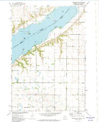
1972 Map of Beardsley NW
USGS Topo · Published 1974About this map
Lake Traverse dominates this 1970s landscape, serving as the natural boundary between South Dakota and Minnesota and the Roberts and Traverse county lines. The shoreline is punctuated by several small landforms including Skunk Island, Carlson Island, and Jackson Island, while Diamond Spring sits tucked along the northern reaches of the reservoir. The topography transitions from the water's edge into the townships of Windsor and Bryant, where the Sisseton Indian Reservation Boundary marks a significant cultural and political line across the terrain.
Find a feature on this map
20 named features on this map. Tap any name to fly to it.
Don’t see what you’re looking for? This feature index may not catch every label — zoom into the map to look around manually.
Map Details
Editions of this 1972 Beardsley NW Map
This is the sole edition of this map. No revisions or reprints were ever made.
Other maps of this area

1915 · White Rock
USGS Topo · 1:62,500

1916 · Peever
USGS Topo · 1:62,500

1916 · Beardsley
USGS Topo · 1:62,500

1917 · New Effington
USGS Topo · 1:62,500

1918 · Peever
USGS Topo · 1:62,500

1918 · White Rock
USGS Topo · 1:62,500

1918 · Beardsley
USGS Topo · 1:62,500

1953 · Milbank
USGS Topo · 1:250,000

1958 · Milbank
USGS Topo · 1:250,000

1971 · Browns Valley
USGS Topo · 1:24,000