1970s Maps of Fort Pierre, South Dakota
Explore 2 historic maps of Fort Pierre from the 1970s. These maps offer a rare glimpse into what life looked like during the 1970s — showing old roads, neighborhoods, homes, and landmarks that have changed or disappeared over time.
Whether you're researching your family's past, planning a metal detecting trip, or studying how Fort Pierre's landscape evolved across the 1970s, these high-resolution maps are a powerful tool for exploring the history of this region.
- Focus on a specific era: All maps on this page are from the 1970s, giving you a focused view of this time period.
- See what’s changed: Compare century-old streets, trails, and buildings to today's modern landscape using overlays and satellite layers.
- Research with precision: Use these maps for genealogy, historical research, land use analysis, or educational projects.
- View, download, or print: Maps are fully viewable online in high resolution, and can be downloaded or printed for your own records.
Start exploring Fort Pierre's history through authentic maps from the 1970s. This is your window into the past.
Fort Pierre, SD maps
(2)- 1973 Map of Pierre, 1976 Print
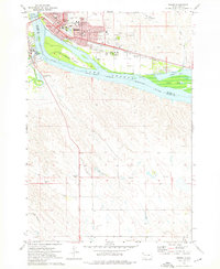 1973 Pierre1976 Print · USGSThe South Dakota capital and Fort Pierre are captured here in the early seventies, flanking the Missouri River at its junction with the Bad River. Genealogists and local historians can trace civic landmarks like the Capitol, the Pierre Indian Sch, and the Riverside Cemetery amidst the river islands and rail lines.
 - 1973 Map of Oahe Dam, 1976 Print
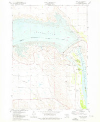 1973 Oahe Dam1976 Print · USGSStanley and Hughes counties were transformed in the early seventies by the massive Missouri River reservoirs created by the Oahe Dam. Researchers can trace the submerged river boundary and find local landmarks like the Scotty Philip Cem, the Old RR Grade, and Singleton Landing Field.
End of results
Showing maps 1-2 of 2
Top cities near Fort Pierre
Frequently asked questions
- What are the different types of historical maps available for Fort Pierre?
- What is the oldest map of Fort Pierre?
- Where can I purchase historical maps of Fort Pierre for my home or office?
- Where can I download high-res historical maps of Fort Pierre?
- Are there historical topographic maps available for Fort Pierre?
- Is there historical aerial imagery available for Fort Pierre?
- Where are historical maps of Fort Pierre sourced from?