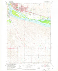
1973 Map of Pierre
USGS Topo · Published 1976About this map
Pierre stands at the confluence of the Missouri River and the Bad River during the early 1970s, serving as the civic and institutional heart of South Dakota. The map captures the city's complex infrastructure, from the Capitol and City Hall to an extensive network of educational facilities including Riggs Sch, Buchanan Sch, and the Pierre Indian Sch. Transportation is dominated by the Chicago and North Western railroad and the Pierre Municipal Airport, while the riverfront is defined by La Framboise Island and the expansive Lake Sharpe. South of the river, the landscape transitions into open terrain marked by the Old Indian Treaty Boundary, which runs through the heart of Stanley County. This survey provides a precise look at the capital city before modern suburban expansion significantly altered the surrounding bluffs and riverbanks.
Find a feature on this map
47 named features on this map. Tap any name to fly to it.
Don’t see what you’re looking for? This feature index may not catch every label — zoom into the map to look around manually.
Map Details
Editions of this 1973 Pierre Map
This is the sole edition of this map. No revisions or reprints were ever made.
Other maps of this area

1924 · Pierre
USGS Topo · 1:62,500

1934 · Canning
USGS Topo · 1:48,000

1937 · Canning
USGS Topo · 1:62,500

1953 · Pierre SW
USGS Topo · 1:24,000

1953 · Pierre 3 NW
USGS Topo · 1:24,000

1954 · Pierre
USGS Topo · 1:250,000

1958 · Pierre
USGS Topo · 1:250,000

1967 · Pierre NE
USGS Topo · 1:24,000
1967 · Canning NW
USGS Topo · 1:24,000

1967 · Ft. George Butte NW
USGS Topo · 1:24,000