
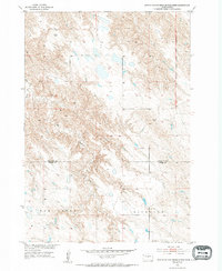
1953 Map of Pierre 3 NW
USGS Topo · Published 1955About this map
Old Boundary Lower Brule Indian Reservation marks the eastern edge of this mid-century landscape where Stanley and Jones Counties meet. The terrain is defined by the drainage systems of War Creek and Richland, illustrating the complex topography of the Missouri River Basin development area. Small named locales such as Bradley, Wooten, and Rose are scattered across the sheet, likely representing ranching headquarters or family landmarks common to this period of South Dakota history. The West Branch weaves through the western portion of the quadrangle, highlighting the importance of water access in this high-plains environment. This 1953 field check captures the area before modern infrastructure altered the rural character of the region, providing a specific look at the land divisions and geographic markers of the era.
Find a feature on this map
8 named features on this map. Tap any name to fly to it.
Don’t see what you’re looking for? This feature index may not catch every label — zoom into the map to look around manually.
Map Details
Editions of this 1953 Pierre 3 NW Map
2 editions found
Other maps of this area

1924 · Pierre
USGS Topo · 1:62,500

1937 · Oahe
USGS Topo · 1:62,500

1953 · Teton
USGS Topo · 1:24,000

1953 · Pierre SW
USGS Topo · 1:24,000

1953 · Wendte NE
USGS Topo · 1:24,000

1954 · Pierre
USGS Topo · 1:250,000

1958 · Pierre
USGS Topo · 1:250,000

1972 · Pierre 3 SW
USGS Topo · 1:24,000

1972 · Pierre 3 SE
USGS Topo · 1:24,000
1972 · Wendte SE
USGS Topo · 1:24,000