1960s Maps of Virginia Township, South Dakota
Explore 4 historic maps of Virginia Township from the 1960s. These maps offer a rare glimpse into what life looked like during the 1960s — showing old roads, neighborhoods, homes, and landmarks that have changed or disappeared over time.
Whether you're researching your family's past, planning a metal detecting trip, or studying how Virginia Township's landscape evolved across the 1960s, these high-resolution maps are a powerful tool for exploring the history of this region.
- Focus on a specific era: All maps on this page are from the 1960s, giving you a focused view of this time period.
- See what’s changed: Compare century-old streets, trails, and buildings to today's modern landscape using overlays and satellite layers.
- Research with precision: Use these maps for genealogy, historical research, land use analysis, or educational projects.
- View, download, or print: Maps are fully viewable online in high resolution, and can be downloaded or printed for your own records.
Start exploring Virginia Township's history through authentic maps from the 1960s. This is your window into the past.
Virginia Township, SD maps
(4)- 1968 Map of Alcester SE, 1970 Print
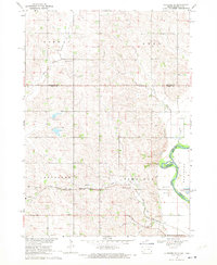 1968 Alcester SE1970 Print · USGSThe borderlands of Union County, South Dakota, are captured in the late sixties as the Big Sioux River snakes past the township of Alcester. Researchers can trace rural landmarks from the Nathanael Cem to the Chicago and North Western rail line.
 - 1968 Map of Hawarden North, 1971 Print
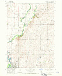 1968 Hawarden North1971 Print · USGSThe river valley at the Iowa-South Dakota border was a vital rail and agricultural corridor in the late sixties. Genealogists and local historians can trace the foundations of Hawarden and find specific landmarks like Calvary Cem and the old Townhall.
 - 1969 Map of Chatsworth, 1971 Print
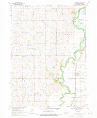 1969 Chatsworth1971 Print · USGSThe Big Sioux River valley comes alive in the late sixties as it winds along the South Dakota and Iowa border. Trace the old Milwaukee Road rail line through Chatsworth and locate local landmarks like Union Creek Ch or Old Big Springs Cem.
 - 1969 Map of Hawarden South, 1971 Print
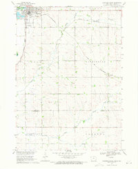 1969 Hawarden South1971 Print · USGSSioux County farming and rail transit are captured here in the late sixties as the region supported the Missouri River Basin development. Researchers can trace the dual rail lines of the Chicago and North Western and the Chicago Milwaukee St Paul and Pacific near Hawarden and McNally.
End of results
Showing maps 1-4 of 4
Top cities near Virginia Township
- Rock Valley historical maps
- Hawarden historical maps
- Akron historical maps
- Alcester historical maps
- Ireton historical maps
- Hudson historical maps
See more
Frequently asked questions
- What are the different types of historical maps available for Virginia Township?
- What is the oldest map of Virginia Township?
- Where can I purchase historical maps of Virginia Township for my home or office?
- Where can I download high-res historical maps of Virginia Township?
- Are there historical topographic maps available for Virginia Township?
- Is there historical aerial imagery available for Virginia Township?
- Where are historical maps of Virginia Township sourced from?