1940s Maps of Benton County, Tennessee
Explore 7 historic maps of Benton County from the 1940s. These maps offer a rare glimpse into what life looked like during the 1940s — showing old roads, neighborhoods, homes, and landmarks that have changed or disappeared over time.
Whether you're researching your family's past, planning a metal detecting trip, or studying how Benton County's landscape evolved across the 1940s, these high-resolution maps are a powerful tool for exploring the history of this region.
- Focus on a specific era: All maps on this page are from the 1940s, giving you a focused view of this time period.
- See what’s changed: Compare century-old streets, trails, and buildings to today's modern landscape using overlays and satellite layers.
- Research with precision: Use these maps for genealogy, historical research, land use analysis, or educational projects.
- View, download, or print: Maps are fully viewable online in high resolution, and can be downloaded or printed for your own records.
Start exploring Benton County's history through authentic maps from the 1940s. This is your window into the past.
Benton County, TN maps
(7)- 1940 Map of Manleyville
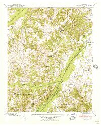 1940 Manleyville1940 Print · USGSThe West Tennessee river bottoms and hill country are shown just before the war, when the Big Sandy River valley was a patchwork of small farms and family cemeteries. Trace vanished local landmarks like Smith College, McDavid Sch, and the isolated Rushing Chapel among the network of drainage ditches.
 - 1941 Map of Manleyville
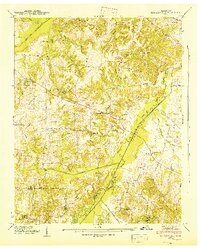 1941 Manleyville1941 Print · USGSHenry and Benton County borderlands come into focus in the early 1940s, showing a rural landscape organized around the Big Sandy River. Researchers can locate several country schools and cemeteries, including Smith College, McDavid School, and Kemp Cemetery.
 - 1949 Map of Daniels Landing, 1953 Print
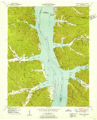
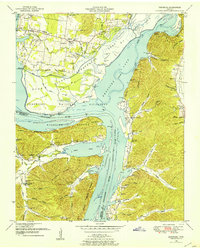
 1949 Daniels Landing1953 Print · USGSWest Tennessee river life is captured here in the late 1940s as the valley adapted to the creation of Kentucky Lake. Researchers can trace old family sites and river landings such as Daniels Landing, Blue Creek School, and Britta Chapel.3 unique versions available
 - 1949 Map of Harmon Creek, 1953 Print
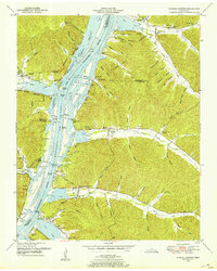
 1949 Harmon Creek1953 Print · USGSThe Tennessee River valley at the junction of Benton and Humphreys counties is shown here shortly after the reservoir's formation. Researchers can locate numerous family burial sites and rural centers like Harmon Creek Church, St John School, and Melton Cem.3 unique versions available
 - 1949 Map of Hustburg, 1953 Print
 1949 Hustburg1953 Print · USGSHumphreys and Benton Counties are shown here during the transformative years following the filling of Kentucky Lake. Genealogists and local historians can locate dozens of family cemeteries and rural school sites like Tribble Sch and Byrd Sch.4 unique versions available
 - 1949 Map of Poplar Creek, 1953 Print
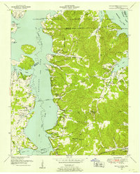 1949 Poplar Creek1953 Print · USGSBenton County river life and upland farming are documented here just after the war, as the reservoir system reshaped the shoreline. Researchers can locate dozens of family sites and landmarks, including Culpepper Cem, Antioch Boat Harbor, and the Louisville and Nashville rail stop at Faxon.3 unique versions available
 - 1949 Map of Sugar Tree, 1953 Print
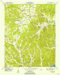 1949 Sugar Tree1953 Print · USGSBenton and Decatur Counties are captured in the late 1940s, showing a landscape of deep hollows and high ridges along the Tennessee River. Genealogists can trace family names at Manley Chapel Cemetery and locate vanished local landmarks like Spences Store or Mellwain.2 unique versions available
End of results
Showing maps 1-7 of 7
Top cities of Benton County
Frequently asked questions
- What are the different types of historical maps available for Benton County?
- What is the oldest map of Benton County?
- Where can I purchase historical maps of Benton County for my home or office?
- Where can I download high-res historical maps of Benton County?
- Are there historical topographic maps available for Benton County?
- Is there historical aerial imagery available for Benton County?
- Where are historical maps of Benton County sourced from?