1900s (20th Century) Maps of Halls, Tennessee
Explore 6 historic maps of Halls from the 1900s (20th Century). These maps offer a rare glimpse into what life looked like during the 1900s — showing old roads, neighborhoods, homes, and landmarks that have changed or disappeared over time.
Whether you're researching your family's past, planning a metal detecting trip, or studying how Halls's landscape evolved across the 1900s, these high-resolution maps are a powerful tool for exploring the history of this region.
- Focus on a specific era: All maps on this page are from the 1900s, giving you a focused view of this time period.
- See what’s changed: Compare century-old streets, trails, and buildings to today's modern landscape using overlays and satellite layers.
- Research with precision: Use these maps for genealogy, historical research, land use analysis, or educational projects.
- View, download, or print: Maps are fully viewable online in high resolution, and can be downloaded or printed for your own records.
Start exploring Halls's history through authentic maps from the 1900s. This is your window into the past.
Halls, TN maps
(6)- 1936 Map of Manleyville
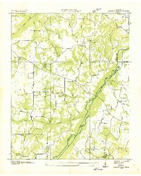 1936 Manleyville1936 Print · USGSHenry County during the mid-1930s shows a landscape of small farming communities organized around local schools and rural churches. Researchers can locate family landmarks like Mc Davids Cem, Spring Creek Sch, and the community at Manleyville.
 - 1940 Map of Manleyville
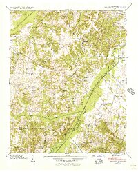 1940 Manleyville1940 Print · USGSThe West Tennessee river bottoms and hill country are shown just before the war, when the Big Sandy River valley was a patchwork of small farms and family cemeteries. Trace vanished local landmarks like Smith College, McDavid Sch, and the isolated Rushing Chapel among the network of drainage ditches.
 - 1941 Map of Manleyville
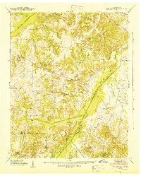 1941 Manleyville1941 Print · USGSHenry and Benton County borderlands come into focus in the early 1940s, showing a rural landscape organized around the Big Sandy River. Researchers can locate several country schools and cemeteries, including Smith College, McDavid School, and Kemp Cemetery.
 - 1956 Map of Dyersburg, 1960 Print
 1956 Dyersburg1960 Print · USGSThe Four Rivers region comes alive in the mid-fifties, capturing the intricate borderlands of Tennessee, Kentucky, and Missouri. Genealogists and historians can trace the rail-and-river networks connecting Dyersburg, Caruthersville, and the shoreline of Reelfoot Lake.4 unique versions available
 - 1965 Map of Manleyville, 1967 Print
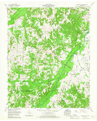 1965 Manleyville1967 Print · USGSThe rural uplands of Henry County meet the engineered bottomlands of the Big Sandy River in the mid-1960s. Genealogists can trace family landmarks like Rowden Cem and Manleys Chapel Cem, while historians can locate the Reynoldsburg Road and the Big Sandy River Dewatering Area.2 unique versions available
 - 1986 Map of McKenzie
 1986 McKenzie1986 Print · USGSWest Tennessee in the mid-eighties was a landscape defined by its deep river forks and the massive waters of Kentucky Lake. Researchers can trace the rail lines of the Louisville & Nashville RR and find local landmarks from Skullbone to the Paris Landing State Park.3 unique versions available
End of results
Showing maps 1-6 of 6
Top cities near Halls
- Paris historical maps
- Huntingdon historical maps
- Camden historical maps
- New Johnsonville historical maps
- Bruceton historical maps
- Hollow Rock historical maps
See more
Frequently asked questions
- What are the different types of historical maps available for Halls?
- What is the oldest map of Halls?
- Where can I purchase historical maps of Halls for my home or office?
- Where can I download high-res historical maps of Halls?
- Are there historical topographic maps available for Halls?
- Is there historical aerial imagery available for Halls?
- Where are historical maps of Halls sourced from?