1960s Maps of Alcoa, Tennessee
Explore 8 historic maps of Alcoa from the 1960s. These maps offer a rare glimpse into what life looked like during the 1960s — showing old roads, neighborhoods, homes, and landmarks that have changed or disappeared over time.
Whether you're researching your family's past, planning a metal detecting trip, or studying how Alcoa's landscape evolved across the 1960s, these high-resolution maps are a powerful tool for exploring the history of this region.
- Focus on a specific era: All maps on this page are from the 1960s, giving you a focused view of this time period.
- See what’s changed: Compare century-old streets, trails, and buildings to today's modern landscape using overlays and satellite layers.
- Research with precision: Use these maps for genealogy, historical research, land use analysis, or educational projects.
- View, download, or print: Maps are fully viewable online in high resolution, and can be downloaded or printed for your own records.
Start exploring Alcoa's history through authentic maps from the 1960s. This is your window into the past.
Alcoa, TN maps
(8)- 1960 Map of Knoxville
 1960 Knoxville1960 Print · USGSThe Southern Appalachians come alive in the 1950s, showing the intersection of new national park tourism and deep-rooted mountain industry. Trace old rail lines like the Clinchfield RR and find high-altitude landmarks from Mt Le Conte to the Cherokee Indian Reservation.2 unique versions available
 - 1960 Map of Chattanooga
 1960 Chattanooga1960 Print · USGSSoutheast Tennessee and the southern Appalachians are shown here at the height of the river-management era. You can trace the valley rail lines and locate Lookout Mountain and the expansive waters of Chickamauga Reservoir.
 - 1964 Map of Chattanooga
 1964 Chattanooga1964 Print · USGSSoutheast Tennessee and the western Carolinas appear in the mid-sixties as a powerhouse of river-driven industry and mountain wilderness. Genealogists and historians can trace rail-town lineages along the Southern Ry or locate family landmarks near Watts Bar Lake and Tellico Plains.
 - 1964 Map of Knoxville
 1964 Knoxville1964 Print · USGSThe Southern Appalachians and Great Smokies are captured here during the mid-sixties, showing the rugged borderlands of Tennessee and North Carolina. Researchers can trace historic mountain routes like U S 441, the expanse of Pisgah National Forest, and the growing footprints of Asheville and Knoxville.
 - 1966 Map of Knoxville, 1968 Print
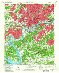 1966 Knoxville1968 Print · USGSKnoxville in the mid-sixties is a city in transition, as new interstate highways begin to cut through historic urban neighborhoods and older rail corridors. Researchers can trace the footprints of Knoxville College, Old Gray Cem, and the riverfront campus of the University of Tennessee.2 unique versions available
 - 1966 Map of Maryville, 1968 Print
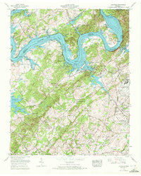
 1966 Maryville1968 Print · USGSMid-century Maryville and Alcoa are captured during a period of significant growth and aviation expansion. Researchers can trace the footprints of Maryville College, the Mc Ghee Tyson Air Force Base, and old crossings like Brakebill Island.
 - 1966 Map of Bearden, 1968 Print
 1966 Bearden1968 Print · USGSWestern Knoxville and the Beaver Valley are captured in the mid-sixties during a transformative era of suburban growth. Genealogists and historians can trace the transition from rural landmarks like Beaver Ridge Cem to rising neighborhoods such as West Hills and Rocky Hill.
 - 1968 Map of Louisville, 1972 Print
 1968 Louisville1972 Print · USGSThe Blount and Knox county borderlands are captured here in the late sixties, where the rising waters of Fort Loudoun Lake met established rail and military hubs. Trace family history at Miser Station, Mahoney Mill, or the Louisville Cem.5 unique versions available
End of results
Showing maps 1-8 of 8
Top cities near Alcoa
- Knoxville historical maps
- Maryville historical maps
- Oak Ridge historical maps
- Farragut historical maps
- Powell historical maps
- Mascot historical maps
See more
Top neighborhoods of Alcoa
- Farrport historical maps
- Hannum Addition historical maps
- Harth Addition historical maps
- Lakemont historical maps
- Vose historical maps
- Oldfield Addition historical maps
See more
Frequently asked questions
- What are the different types of historical maps available for Alcoa?
- What is the oldest map of Alcoa?
- Where can I purchase historical maps of Alcoa for my home or office?
- Where can I download high-res historical maps of Alcoa?
- Are there historical topographic maps available for Alcoa?
- Is there historical aerial imagery available for Alcoa?
- Where are historical maps of Alcoa sourced from?