1950s Maps of Kinzel Springs, Tennessee
Explore 3 historic maps of Kinzel Springs from the 1950s. These maps offer a rare glimpse into what life looked like during the 1950s — showing old roads, neighborhoods, homes, and landmarks that have changed or disappeared over time.
Whether you're researching your family's past, planning a metal detecting trip, or studying how Kinzel Springs's landscape evolved across the 1950s, these high-resolution maps are a powerful tool for exploring the history of this region.
- Focus on a specific era: All maps on this page are from the 1950s, giving you a focused view of this time period.
- See what’s changed: Compare century-old streets, trails, and buildings to today's modern landscape using overlays and satellite layers.
- Research with precision: Use these maps for genealogy, historical research, land use analysis, or educational projects.
- View, download, or print: Maps are fully viewable online in high resolution, and can be downloaded or printed for your own records.
Start exploring Kinzel Springs's history through authentic maps from the 1950s. This is your window into the past.
Kinzel Springs, TN maps
(3)- 1953 Map of Kinzel Springs, 1955 Print
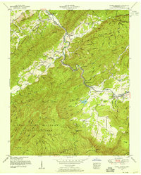 1953 Kinzel Springs1955 Print · USGSBlount County at the edge of the Smokies comes alive in the early fifties as the valley floor meets the mountain ridges. Researchers can locate vanished rural institutions and early transport lines like the Little River RR, Laws School, and Kinzel Springs.5 unique versions available
 - 1955 Map of Knoxville
 1955 Knoxville1955 Print · USGSThe Southern Appalachians and the Smoky Mountains are shown here at a peak of mid-century development and conservation. Genealogists and historians can trace the early road networks connecting Gatlinburg, Waynesville, and the Cherokee Indian Reservation across the high ridges.
 - 1957 Map of Knoxville, 1966 Print
 1957 Knoxville1966 Print · USGSThe Southern Appalachians of Tennessee and North Carolina are mapped here during the mid-twentieth century as new highways reached the high country. Genealogists and historians can trace the topography between Knoxville and Asheville, locating family landmarks near Fontana Lake or along the Blue Ridge Parkway.4 unique versions available
End of results
Showing maps 1-3 of 3
Top cities near Kinzel Springs
- Knoxville historical maps
- Maryville historical maps
- Sevierville historical maps
- Alcoa historical maps
- Pigeon Forge historical maps
- Louisville historical maps
See more
Frequently asked questions
- What are the different types of historical maps available for Kinzel Springs?
- What is the oldest map of Kinzel Springs?
- Where can I purchase historical maps of Kinzel Springs for my home or office?
- Where can I download high-res historical maps of Kinzel Springs?
- Are there historical topographic maps available for Kinzel Springs?
- Is there historical aerial imagery available for Kinzel Springs?
- Where are historical maps of Kinzel Springs sourced from?