1960s Maps of Pine Hill, Tennessee
Explore 3 historic maps of Pine Hill from the 1960s. These maps offer a rare glimpse into what life looked like during the 1960s — showing old roads, neighborhoods, homes, and landmarks that have changed or disappeared over time.
Whether you're researching your family's past, planning a metal detecting trip, or studying how Pine Hill's landscape evolved across the 1960s, these high-resolution maps are a powerful tool for exploring the history of this region.
- Focus on a specific era: All maps on this page are from the 1960s, giving you a focused view of this time period.
- See what’s changed: Compare century-old streets, trails, and buildings to today's modern landscape using overlays and satellite layers.
- Research with precision: Use these maps for genealogy, historical research, land use analysis, or educational projects.
- View, download, or print: Maps are fully viewable online in high resolution, and can be downloaded or printed for your own records.
Start exploring Pine Hill's history through authentic maps from the 1960s. This is your window into the past.
Pine Hill, TN maps
(3)- 1960 Map of Chattanooga
 1960 Chattanooga1960 Print · USGSSoutheast Tennessee and the southern Appalachians are shown here at the height of the river-management era. You can trace the valley rail lines and locate Lookout Mountain and the expansive waters of Chickamauga Reservoir.
 - 1964 Map of Chattanooga
 1964 Chattanooga1964 Print · USGSSoutheast Tennessee and the western Carolinas appear in the mid-sixties as a powerhouse of river-driven industry and mountain wilderness. Genealogists and historians can trace rail-town lineages along the Southern Ry or locate family landmarks near Watts Bar Lake and Tellico Plains.
 - 1967 Map of Mc Donald, 1970 Print
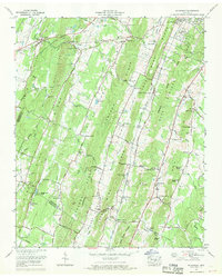 1967 Mc Donald1970 Print · USGSBradley and Hamilton counties during the late sixties are captured here in meticulous detail, showing the rural communities between the ridges. Researchers can trace family sites near McDonald, Bethel Ch, and the Lee Cem while following old railroad spurs at Marble Switch.3 unique versions available
End of results
Showing maps 1-3 of 3
Top cities near Pine Hill
- Chattanooga historical maps
- Cleveland historical maps
- East Ridge historical maps
- Soddy-Daisy historical maps
- Fort Oglethorpe historical maps
- Collegedale historical maps
See more
Frequently asked questions
- What are the different types of historical maps available for Pine Hill?
- What is the oldest map of Pine Hill?
- Where can I purchase historical maps of Pine Hill for my home or office?
- Where can I download high-res historical maps of Pine Hill?
- Are there historical topographic maps available for Pine Hill?
- Is there historical aerial imagery available for Pine Hill?
- Where are historical maps of Pine Hill sourced from?