Old Maps of Deerfield, Campbell County for Genealogy
Trace your family roots with 31 historic maps of Deerfield. These high-res maps reveal old neighborhoods, homesites, landmarks, and streets — helping you uncover where your ancestors lived and how the area evolved over time.
- Explore historic neighborhoods: Identify where your relatives may have lived in the 1800s or 1900s.
- Compare maps over time: Trace the changes in streets, buildings, and landmarks for multi-generational research.
- Perfect for genealogy & ancestry research: Used by family historians and researchers to map out lineage and migration.
These maps are an incredible resource for exploring your personal connection to Deerfield's past.
Deerfield, Campbell County maps
(31)- 1893 Map of Briceville
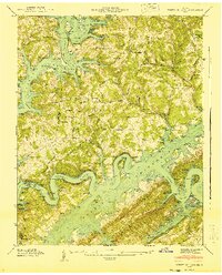
 1893 Briceville1893 Print · USGSThe northern Tennessee coalfields and valleys come to life in the 1890s, when mining and rail were transforming the ridges of the Cumberland. Local historians can trace the paths of the Knoxville and Ohio R. R. and early settlements like Jacksboro, Coal Creek, and Oliver Springs.
 - 1895 Map of Briceville
 1895 Briceville1895 Print · USGSThe Cumberland Mountains and Powell Valley met a rapidly expanding railroad network in the late nineteenth century. Trace early industrial footprints and family-named hollows from Briceville and Clinton to the coal-rich slopes of Big Mountain.
 - 1896 Map of Briceville
 1896 Briceville1896 Print · USGSEast Tennessee's coal and rail corridors are captured here in the late nineteenth century as the industrial landscape of the Cumberland Plateau matured. Researchers can trace early family homesteads and transport hubs through Briceville, Clinton, and the Southern RR line.6 unique versions available
 - 1897 Map of Maynardville
 1897 Maynardville1897 Print · USGSEast Tennessee in the late nineteenth century was a landscape of high ridges and vital river fords. Genealogists and historians can trace old homesteads and transit hubs like Nances Ferry, the Lead Mine at New Prospect, and Massongills Mill.
 - 1900 Map of Maynardville
 1900 Maynardville1900 Print · USGSEast Tennessee was a world of river fords and mountain gaps at the turn of the century, dominated by the winding Clinch and Powell rivers. Genealogists can trace family roots through specific landmarks like Massongills Mill, Church Grove, and Sharps Chapel.4 unique versions available
 - 1936 Map of White Hollow
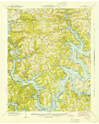
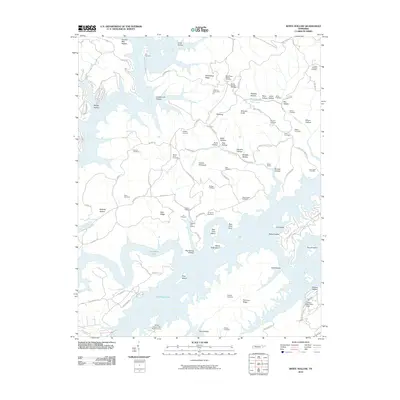
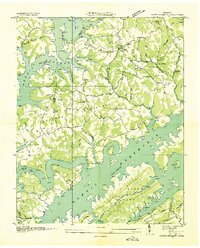 1936 White Hollow1936 Print · USGSUnion County enters a period of massive change in the mid-thirties as the Tennessee Valley Authority fills the new reservoir. Researchers can trace submerged landmarks and family sites like Wilson Mill, Lays Cem, and Mossy Spring Sch.
 - 1936 Map of La Follette
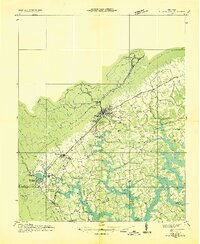 1936 La Follette1936 Print · USGSThe Powell Valley is shown during the early years of the Tennessee Valley Authority as the new shoreline of Norris Reservoir begins to take shape. Researchers can locate family landmarks like Bakers Forge Memorial Cem and coal infrastructure at Indian Creek Mines.
 - 1936 Map of Mc Lean Rock
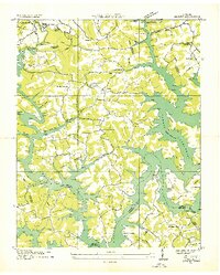
 1936 Mc Lean Rock1936 Print · USGSUnion and Claiborne counties appear just as the Tennessee Valley Authority was reshaping the land in the mid-1930s. Researchers can locate family roots at Rose Hill Ch & Cem, trace the early operations of Lead Mine, or find the historic Speedwell Academy.
 - 1936 Map of Demory
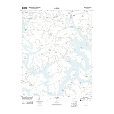
 1936 Demory1936 Print · USGSAs the Tennessee Valley Authority reshaped the region in the mid-1930s, this survey documented the new shoreline of Norris Reservoir. Genealogists can trace community landmarks like Bakers Forge Memorial Cem, Demory Ch, and Alder Springs Sch.
 - 1941 Map of White Hollow
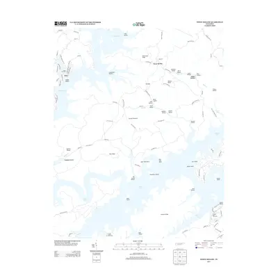
 1941 White Hollow1941 Print · USGSUnion County is seen here during the early years of the Norris Reservoir, when newly formed shorelines met established ridge-top communities. Genealogists can locate family sites like Mc Carty Cem, study the Mt Olive Sch, or find the Hickory Star Landing riverfront.
 - 1941 Map of Demory
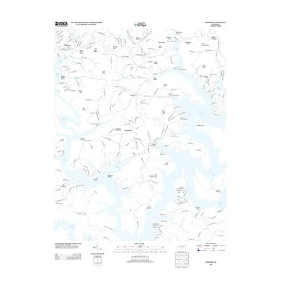
 1941 Demory1941 Print · USGSIn the early 1940s, the Powell and Clinch River valleys were undergoing a massive transformation as the Norris Reservoir reached its early extent. Genealogists can locate family landmarks like Baker Forge Memorial Cem and Woodward Cem near the settlements of Demory and Grantsboro.2 unique versions available
 - 1952 Map of Demory
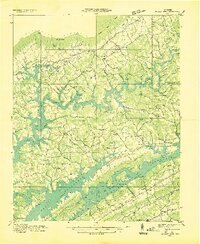
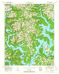 1952 Demory1952 Print · USGSThe confluence of the Clinch and Powell Rivers in Campbell County is shown here following the creation of Norris Lake. Genealogists and local historians can locate dozens of family burial grounds and rural institutions like the Baker Forge Memorial Cemetery, Grantsboro Cemetery, and Demory Church.4 unique versions available
 - 1952 Map of White Hollow, 1955 Print
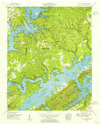 1952 White Hollow1955 Print · USGSSurrounding the intricate fingers of Norris Lake in the early 1950s, this area shows a landscape transformed by water and conservation. Researchers can trace dozens of family-named landmarks and cemeteries like Lays Cemetery and New Mossy Spring Cemetery near Lindamood.4 unique versions available
 - 1955 Map of Johnson City
 1955 Johnson City1955 Print · USGSEast Tennessee and the bordering highlands of Virginia and Kentucky appear here during the post-war industrial boom. You can trace the complex network of mountain ridges and new TVA lakes, from Johnson City to the coalfields near Middlesboro and Lynch.
 - 1956 Map of Corbin, 1966 Print
 1956 Corbin1966 Print · USGSThe Kentucky and Tennessee borderlands are captured here in the mid-fifties, showing the region's shift toward modern interstate travel and reservoir development. Genealogists and historians can trace old community lines near Albany and Monticello or locate early rail junctions along the Southern and Tennessee Central lines.3 unique versions available
 - 1957 Map of Johnson City, 1966 Print
 1957 Johnson City1966 Print · USGSUpper East Tennessee and Southwest Virginia are shown here during the mid-sixties transition of the Appalachians. Researchers can trace the industrial rail hubs of Kingsport, the sprawling waters of Cherokee Lake, and the historic Cumberland Gap.
 - 1958 Map of Corbin
 1958 Corbin1958 Print · USGSThe Upper Cumberland borderlands appear in the late 1950s as massive reservoirs and early atomic-era growth reshape the region. Trace family roots and vanished landmarks near Lake Cumberland, Oak Ridge, and the Cumberland National Forest.
 - 1960 Map of Johnson City
 1960 Johnson City1960 Print · USGSUpper East Tennessee and the surrounding tri-state area are shown in the mid-fifties during the height of the TVA reservoir era. Trace the industrial rail lines of the Southern and Louisville and Nashville between Kingsport and Johnson City.
 - 1963 Map of Johnson City
 1963 Johnson City1963 Print · USGSThe Tri-Cities and the surrounding Appalachian ridges are shown in detail during the early sixties, highlighting the era's vital rail and river networks. Genealogists and historians can trace the routes of the Clinchfield RR and locate settlements from Rogersville to Elizabethton.
 - 1979 Map of Oakridge, 1980 Print
 1979 Oakridge1980 Print · USGSThe eastern Tennessee highlands are captured here in the late 1970s, showcasing a landscape of coal mining and mountain conservation. Genealogists and researchers can locate family landmarks such as Potter Cem, Sunbright Sch, and the historic settlement of Rugby.
 - 1981 Map of Morristown
 1981 Morristown1981 Print · USGSEast Tennessee's ridge-and-valley corridor is captured here in the early eighties, showing the region's transformation by TVA reservoirs. Genealogists and historians can trace family locations near Alpha Ch, follow the Southern Railway, or locate the Young Mine.
 - 2010 Map of Demory, 2010 Print
 2010 Demory2010 Print · USGSCovers Deerfield, including La Follette, Demory, and other nearby areas
 - 2010 Map of White Hollow, 2010 Print
 2010 White Hollow2010 Print · USGSCovers Deerfield, including Alder, Anderson County, and other nearby areas
 - 2013 Map of Demory, 2013 Print
 2013 Demory2013 Print · USGSCovers Deerfield, including La Follette, Demory, and other nearby areas
 - 2013 Map of White Hollow, 2013 Print
 2013 White Hollow2013 Print · USGSCovers Deerfield, including Alder, Anderson County, and other nearby areas
Showing maps 1-25 of 31
Frequently asked questions
- What are the different types of historical maps available for Deerfield?
- What is the oldest map of Deerfield?
- Where can I purchase historical maps of Deerfield for my home or office?
- Where can I download high-res historical maps of Deerfield?
- Are there historical topographic maps available for Deerfield?
- Is there historical aerial imagery available for Deerfield?
- Where are historical maps of Deerfield sourced from?