1950s Maps of Deerfield, Campbell County
Explore 6 historic maps of Deerfield from the 1950s. These maps offer a rare glimpse into what life looked like during the 1950s — showing old roads, neighborhoods, homes, and landmarks that have changed or disappeared over time.
Whether you're researching your family's past, planning a metal detecting trip, or studying how Deerfield's landscape evolved across the 1950s, these high-resolution maps are a powerful tool for exploring the history of this region.
- Focus on a specific era: All maps on this page are from the 1950s, giving you a focused view of this time period.
- See what’s changed: Compare century-old streets, trails, and buildings to today's modern landscape using overlays and satellite layers.
- Research with precision: Use these maps for genealogy, historical research, land use analysis, or educational projects.
- View, download, or print: Maps are fully viewable online in high resolution, and can be downloaded or printed for your own records.
Start exploring Deerfield's history through authentic maps from the 1950s. This is your window into the past.
Deerfield, Campbell County maps
(6)- 1952 Map of Demory
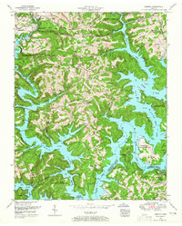 1952 Demory1952 Print · USGSThe confluence of the Clinch and Powell Rivers in Campbell County is shown here following the creation of Norris Lake. Genealogists and local historians can locate dozens of family burial grounds and rural institutions like the Baker Forge Memorial Cemetery, Grantsboro Cemetery, and Demory Church.4 unique versions available
 - 1952 Map of White Hollow, 1955 Print
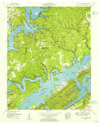 1952 White Hollow1955 Print · USGSSurrounding the intricate fingers of Norris Lake in the early 1950s, this area shows a landscape transformed by water and conservation. Researchers can trace dozens of family-named landmarks and cemeteries like Lays Cemetery and New Mossy Spring Cemetery near Lindamood.4 unique versions available
 - 1955 Map of Johnson City
 1955 Johnson City1955 Print · USGSEast Tennessee and the bordering highlands of Virginia and Kentucky appear here during the post-war industrial boom. You can trace the complex network of mountain ridges and new TVA lakes, from Johnson City to the coalfields near Middlesboro and Lynch.
 - 1956 Map of Corbin, 1966 Print
 1956 Corbin1966 Print · USGSThe Kentucky and Tennessee borderlands are captured here in the mid-fifties, showing the region's shift toward modern interstate travel and reservoir development. Genealogists and historians can trace old community lines near Albany and Monticello or locate early rail junctions along the Southern and Tennessee Central lines.3 unique versions available
 - 1957 Map of Johnson City, 1966 Print
 1957 Johnson City1966 Print · USGSUpper East Tennessee and Southwest Virginia are shown here during the mid-sixties transition of the Appalachians. Researchers can trace the industrial rail hubs of Kingsport, the sprawling waters of Cherokee Lake, and the historic Cumberland Gap.
 - 1958 Map of Corbin
 1958 Corbin1958 Print · USGSThe Upper Cumberland borderlands appear in the late 1950s as massive reservoirs and early atomic-era growth reshape the region. Trace family roots and vanished landmarks near Lake Cumberland, Oak Ridge, and the Cumberland National Forest.
End of results
Showing maps 1-6 of 6
Frequently asked questions
- What are the different types of historical maps available for Deerfield?
- What is the oldest map of Deerfield?
- Where can I purchase historical maps of Deerfield for my home or office?
- Where can I download high-res historical maps of Deerfield?
- Are there historical topographic maps available for Deerfield?
- Is there historical aerial imagery available for Deerfield?
- Where are historical maps of Deerfield sourced from?