1930s Maps of Deerfield, Campbell County
Explore 4 historic maps of Deerfield from the 1930s. These maps offer a rare glimpse into what life looked like during the 1930s — showing old roads, neighborhoods, homes, and landmarks that have changed or disappeared over time.
Whether you're researching your family's past, planning a metal detecting trip, or studying how Deerfield's landscape evolved across the 1930s, these high-resolution maps are a powerful tool for exploring the history of this region.
- Focus on a specific era: All maps on this page are from the 1930s, giving you a focused view of this time period.
- See what’s changed: Compare century-old streets, trails, and buildings to today's modern landscape using overlays and satellite layers.
- Research with precision: Use these maps for genealogy, historical research, land use analysis, or educational projects.
- View, download, or print: Maps are fully viewable online in high resolution, and can be downloaded or printed for your own records.
Start exploring Deerfield's history through authentic maps from the 1930s. This is your window into the past.
Deerfield, Campbell County maps
(4)- 1936 Map of White Hollow
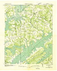 1936 White Hollow1936 Print · USGSUnion County enters a period of massive change in the mid-thirties as the Tennessee Valley Authority fills the new reservoir. Researchers can trace submerged landmarks and family sites like Wilson Mill, Lays Cem, and Mossy Spring Sch.
 - 1936 Map of La Follette
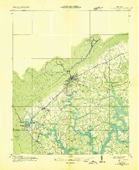 1936 La Follette1936 Print · USGSThe Powell Valley is shown during the early years of the Tennessee Valley Authority as the new shoreline of Norris Reservoir begins to take shape. Researchers can locate family landmarks like Bakers Forge Memorial Cem and coal infrastructure at Indian Creek Mines.
 - 1936 Map of Mc Lean Rock
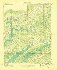 1936 Mc Lean Rock1936 Print · USGSUnion and Claiborne counties appear just as the Tennessee Valley Authority was reshaping the land in the mid-1930s. Researchers can locate family roots at Rose Hill Ch & Cem, trace the early operations of Lead Mine, or find the historic Speedwell Academy.
 - 1936 Map of Demory
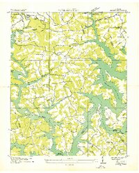 1936 Demory1936 Print · USGSAs the Tennessee Valley Authority reshaped the region in the mid-1930s, this survey documented the new shoreline of Norris Reservoir. Genealogists can trace community landmarks like Bakers Forge Memorial Cem, Demory Ch, and Alder Springs Sch.
End of results
Showing maps 1-4 of 4
Frequently asked questions
- What are the different types of historical maps available for Deerfield?
- What is the oldest map of Deerfield?
- Where can I purchase historical maps of Deerfield for my home or office?
- Where can I download high-res historical maps of Deerfield?
- Are there historical topographic maps available for Deerfield?
- Is there historical aerial imagery available for Deerfield?
- Where are historical maps of Deerfield sourced from?