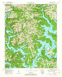
1952 Map of Demory
USGS Topo · Published 1952About this map
Norris Lake dominates this mid-century landscape, its sprawling waters filling the valleys where the Powell River and Clinch River meet. This survey documents the area's transition into a recreation and conservation hub, noted by the presence of the Chuck Swan Management Area and the Cove Creek Wildlife Management Area. Settlements like Demory and Fordtown sit among high ridges such as Negro Ridge and Dividing Ridge, while the cabin areas at Heatherly Point, Pellissippi Point, and Sequoyah Landing indicate the rising prominence of the shoreline for seasonal residency.
Find a feature on this map
87 named features on this map. Tap any name to fly to it.
Don’t see what you’re looking for? This feature index may not catch every label — zoom into the map to look around manually.
Map Details
Editions of this 1952 Demory Map
4 editions found
Other maps of this area

1893 · Briceville
USGS Topo · 1:125,000

1895 · Briceville
USGS Topo · 1:125,000

1896 · Briceville
USGS Topo · 1:125,000

1897 · Maynardville
USGS Topo · 1:125,000

1900 · Maynardville
USGS Topo · 1:125,000

1935 · Well Spring
USGS Topo · 1:24,000

1936 · Gorryton
USGS Topo · 1:48,000

1936 · Ivydell
USGS Topo · 1:24,000

1936 · Jacksboro
USGS Topo · 1:24,000

1936 · White Hollow
USGS Topo · 1:24,000