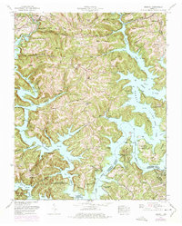
1952 Map of Demory
USGS Topo · Published 1975About this map
The waters of Norris Lake define this mid-century landscape where the Clinch River and Powell River meet. This survey shows the region as it transitioned into a major recreational and conservation hub following the creation of the Tennessee Valley Authority reservoirs. The complex shoreline is dotted with development like the Heatherly Point Cabin Area and Shanghai Dock, alongside established small communities such as Demory and Fordtown. Genealogists will find a significant density of family burial grounds, including Baker Forge Memorial Cemetery, Grantaboro Cemetery, and Sharp Cemetery, many situated on the ridges overlooking the flooded valleys. The eastern portion of the sheet is dominated by the Chuck Swan Wildlife Management Area, preserving a large tract of woodland between the river forks.
Find a feature on this map
65 named features on this map. Tap any name to fly to it.
Don’t see what you’re looking for? This feature index may not catch every label — zoom into the map to look around manually.
Map Details
Editions of this 1952 Demory Map
4 editions found
Other maps of this area

1893 · Briceville
USGS Topo · 1:125,000

1895 · Briceville
USGS Topo · 1:125,000

1896 · Briceville
USGS Topo · 1:125,000

1897 · Maynardville
USGS Topo · 1:125,000

1900 · Maynardville
USGS Topo · 1:125,000

1935 · Well Spring
USGS Topo · 1:24,000

1936 · Gorryton
USGS Topo · 1:48,000

1936 · Ivydell
USGS Topo · 1:24,000

1936 · Jacksboro
USGS Topo · 1:24,000

1936 · White Hollow
USGS Topo · 1:24,000