
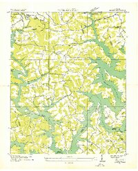
1936 Map of Ivydell
USGS Topo · Published 1936About this map
The industrial corridor of Powell Valley serves as the focal point for this mid-1930s survey, documenting the significant coal mining and transport infrastructure at the base of Cumberland Mountain. The settlement of La Follette sits at the edge of the ridge, where an intricate network of specialized transport systems including an Incline, a Tramway, and the Rex No 2 Mine Conveyor moved resources from the heights down to the L and N RR.
Find a feature on this map
24 named features on this map. Tap any name to fly to it.
Don’t see what you’re looking for? This feature index may not catch every label — zoom into the map to look around manually.
Map Details
Editions of this 1936 Ivydell Map
This is the sole edition of this map. No revisions or reprints were ever made.
Other maps of this area

1890 · Williamsburg
USGS Topo · 1:125,000

1893 · Briceville
USGS Topo · 1:125,000

1894 · Williamsburg
USGS Topo · 1:125,000

1895 · Briceville
USGS Topo · 1:125,000

1896 · Briceville
USGS Topo · 1:125,000

1936 · Block
USGS Topo · 1:24,000

1936 · Jacksboro
USGS Topo · 1:24,000

1936 · Pioneer
USGS Topo · 1:24,000

1936 · La Follette
USGS Topo · 1:48,000
1936 · Demory
USGS Topo · 1:24,000