
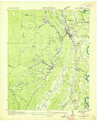
1936 Map of Jacksboro
USGS Topo · Published 1936About this map
Powell Valley serves as the central corridor of this 1936 survey, where the Tennessee Valley Authority was actively reshaping the landscape through the creation of the Norris Reservoir. The map documents a critical transition for Campbell County, showing the projected reservoir boundaries as they encroached upon established farms and communities. The industrial character of the era is evident in the steep terrain of Cumberland Mountain, marked by the High Point Mine and Sun Mines, which were serviced by a network of steep inclines and the Tennessee State railroad. Local life is anchored by numerous rural institutions, including Little Cove Creek Ch, Cumberland View Sch, and the Queener Cem. Near Caryville, the Caryville Dam stands as a focal point of water management, while the southern portion of the sheet is dominated by the prominent rise of Walden Ridge.
Find a feature on this map
60 named features on this map. Tap any name to fly to it.
Don’t see what you’re looking for? This feature index may not catch every label — zoom into the map to look around manually.
Map Details
Editions of this 1936 Jacksboro Map
This is the sole edition of this map. No revisions or reprints were ever made.
Other maps of this area

1893 · Briceville
USGS Topo · 1:125,000

1895 · Briceville
USGS Topo · 1:125,000

1896 · Briceville
USGS Topo · 1:125,000

1936 · Ivydell
USGS Topo · 1:24,000

1936 · Block
USGS Topo · 1:24,000

1936 · Pioneer
USGS Topo · 1:24,000

1936 · Duncan Flats
USGS Topo · 1:24,000

1936 · La Follette
USGS Topo · 1:48,000

1936 · Norris Dam
USGS Topo · 1:48,000
1936 · Coal Creek
USGS Topo · 1:24,000