1900s (20th Century) Maps of Elk Valley, Tennessee
Explore 8 historic maps of Elk Valley from the 1900s (20th Century). These maps offer a rare glimpse into what life looked like during the 1900s — showing old roads, neighborhoods, homes, and landmarks that have changed or disappeared over time.
Whether you're researching your family's past, planning a metal detecting trip, or studying how Elk Valley's landscape evolved across the 1900s, these high-resolution maps are a powerful tool for exploring the history of this region.
- Focus on a specific era: All maps on this page are from the 1900s, giving you a focused view of this time period.
- See what’s changed: Compare century-old streets, trails, and buildings to today's modern landscape using overlays and satellite layers.
- Research with precision: Use these maps for genealogy, historical research, land use analysis, or educational projects.
- View, download, or print: Maps are fully viewable online in high resolution, and can be downloaded or printed for your own records.
Start exploring Elk Valley's history through authentic maps from the 1900s. This is your window into the past.
Elk Valley, TN maps
(8)- 1936 Map of Ivydell
 1936 Ivydell1936 Print · USGSCampbell County’s industrial landscape comes to life in the 1930s as mining operations and rail lines converge near the ridge. Researchers can trace the mechanical legacy of Indian Creek Mines and the specialized Incline and Tramway systems serving Ivydell.
 - 1936 Map of La Follette
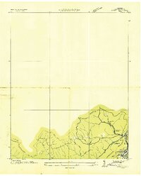
 1936 La Follette1936 Print · USGSThe Powell Valley is shown during the early years of the Tennessee Valley Authority as the new shoreline of Norris Reservoir begins to take shape. Researchers can locate family landmarks like Bakers Forge Memorial Cem and coal infrastructure at Indian Creek Mines.
 - 1946 Map of Ivydell, 1947 Print
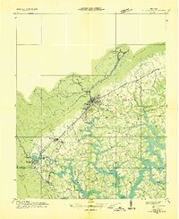
 1946 Ivydell1947 Print · USGSThe Cumberland Mountains of East Tennessee appear here in the 1940s, showing a landscape defined by ridge-top firetowers and deep hollow settlements. Researchers can trace family roots at Samp Meredith Cem or locate lost schoolhouses like Meredith Sch and Flat Rock Sch.
 - 1952 Map of Ivydell, 1954 Print
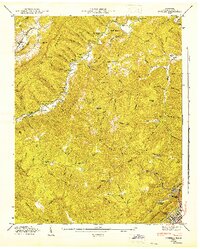
 1952 Ivydell1954 Print · USGSThe Cumberland Mountains of Tennessee are shown in the early 1950s, revealing a landscape defined by deep gaps and family-named ridges. Researchers can trace ancestral connections through several local burying grounds, including Walden Cemetery, or locate the site of Flat Rock School and New Mammoth Cave.2 unique versions available
 - 1956 Map of Corbin, 1966 Print
 1956 Corbin1966 Print · USGSThe Kentucky and Tennessee borderlands are captured here in the mid-fifties, showing the region's shift toward modern interstate travel and reservoir development. Genealogists and historians can trace old community lines near Albany and Monticello or locate early rail junctions along the Southern and Tennessee Central lines.3 unique versions available
 - 1958 Map of Corbin
 1958 Corbin1958 Print · USGSThe Upper Cumberland borderlands appear in the late 1950s as massive reservoirs and early atomic-era growth reshape the region. Trace family roots and vanished landmarks near Lake Cumberland, Oak Ridge, and the Cumberland National Forest.
 - 1973 Map of Ivydell, 1975 Print
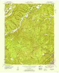
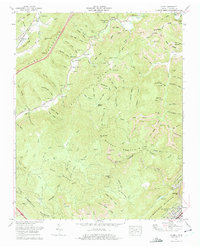 1973 Ivydell1975 Print · USGSCampbell County’s coal country is captured here in the 1970s, showing a landscape defined by industrial strip mines and isolated mountain settlements. Researchers can trace family roots through numerous remote burial sites like Lawson Cem and Broyles Cem or locate the Elk Valley School.
 - 1979 Map of Oakridge, 1980 Print
 1979 Oakridge1980 Print · USGSThe eastern Tennessee highlands are captured here in the late 1970s, showcasing a landscape of coal mining and mountain conservation. Genealogists and researchers can locate family landmarks such as Potter Cem, Sunbright Sch, and the historic settlement of Rugby.
End of results
Showing maps 1-8 of 8
Top cities near Elk Valley
- La Follette historical maps
- LaFollette historical maps
- Oneida historical maps
- Jacksboro historical maps
- Caryville historical maps
- Jellico historical maps
See more
Frequently asked questions
- What are the different types of historical maps available for Elk Valley?
- What is the oldest map of Elk Valley?
- Where can I purchase historical maps of Elk Valley for my home or office?
- Where can I download high-res historical maps of Elk Valley?
- Are there historical topographic maps available for Elk Valley?
- Is there historical aerial imagery available for Elk Valley?
- Where are historical maps of Elk Valley sourced from?