1930s Maps of Cannon County, Tennessee
Explore 2 historic maps of Cannon County from the 1930s. These maps offer a rare glimpse into what life looked like during the 1930s — showing old roads, neighborhoods, homes, and landmarks that have changed or disappeared over time.
Whether you're researching your family's past, planning a metal detecting trip, or studying how Cannon County's landscape evolved across the 1930s, these high-resolution maps are a powerful tool for exploring the history of this region.
- Focus on a specific era: All maps on this page are from the 1930s, giving you a focused view of this time period.
- See what’s changed: Compare century-old streets, trails, and buildings to today's modern landscape using overlays and satellite layers.
- Research with precision: Use these maps for genealogy, historical research, land use analysis, or educational projects.
- View, download, or print: Maps are fully viewable online in high resolution, and can be downloaded or printed for your own records.
Start exploring Cannon County's history through authentic maps from the 1930s. This is your window into the past.
Cannon County, TN maps
(2)- 1936 Map of Beech Grove
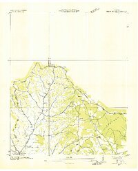 1936 Beech Grove1936 Print · USGSCoffee County rural life in the mid-1930s is detailed here along the winding Garrison Fork and Duck River. Researchers can trace family ties at the Barnes Store, Union Ch, and numerous burial grounds like the Arnold Cem.
 - 1936 Map of Petty Gap
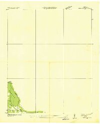 1936 Petty Gap1936 Print · USGSMiddle Tennessee’s highland terrain is captured during the mid-1930s expansion of the Tennessee Valley Authority. Local researchers can trace the specific watershed boundaries of the Tennessee Basin Divide and the course of Perry and Greek creeks.
End of results
Showing maps 1-2 of 2
Top cities of Cannon County
Frequently asked questions
- What are the different types of historical maps available for Cannon County?
- What is the oldest map of Cannon County?
- Where can I purchase historical maps of Cannon County for my home or office?
- Where can I download high-res historical maps of Cannon County?
- Are there historical topographic maps available for Cannon County?
- Is there historical aerial imagery available for Cannon County?
- Where are historical maps of Cannon County sourced from?