1960s Maps of Lavinia, Tennessee
Explore 1 historic maps of Lavinia from the 1960s. These maps offer a rare glimpse into what life looked like during the 1960s — showing old roads, neighborhoods, homes, and landmarks that have changed or disappeared over time.
Whether you're researching your family's past, planning a metal detecting trip, or studying how Lavinia's landscape evolved across the 1960s, these high-resolution maps are a powerful tool for exploring the history of this region.
- Focus on a specific era: All maps on this page are from the 1960s, giving you a focused view of this time period.
- See what’s changed: Compare century-old streets, trails, and buildings to today's modern landscape using overlays and satellite layers.
- Research with precision: Use these maps for genealogy, historical research, land use analysis, or educational projects.
- View, download, or print: Maps are fully viewable online in high resolution, and can be downloaded or printed for your own records.
Start exploring Lavinia's history through authentic maps from the 1960s. This is your window into the past.
Lavinia, TN maps
(1)- 1966 Map of Spring Creek, 1967 Print
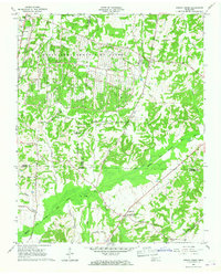 1966 Spring Creek1967 Print · USGSWestern Tennessee at the height of the Cold War is captured here, showing the intersection of rural agriculture and military industry. Trace the massive footprint of the Milan Army Ammunition Plant alongside local landmarks like Latham Chapel and the Illinois Central RR.3 unique versions available
End of results
Showing maps 1-1 of 1
Top cities near Lavinia
- Jackson historical maps
- Humboldt historical maps
- Lexington historical maps
- Huntingdon historical maps
- Medina historical maps
- Three Way historical maps
See more
Frequently asked questions
- What are the different types of historical maps available for Lavinia?
- What is the oldest map of Lavinia?
- Where can I purchase historical maps of Lavinia for my home or office?
- Where can I download high-res historical maps of Lavinia?
- Are there historical topographic maps available for Lavinia?
- Is there historical aerial imagery available for Lavinia?
- Where are historical maps of Lavinia sourced from?