1900s (20th Century) Maps of McKenzie, Tennessee
Explore 7 historic maps of McKenzie from the 1900s (20th Century). These maps offer a rare glimpse into what life looked like during the 1900s — showing old roads, neighborhoods, homes, and landmarks that have changed or disappeared over time.
Whether you're researching your family's past, planning a metal detecting trip, or studying how McKenzie's landscape evolved across the 1900s, these high-resolution maps are a powerful tool for exploring the history of this region.
- Focus on a specific era: All maps on this page are from the 1900s, giving you a focused view of this time period.
- See what’s changed: Compare century-old streets, trails, and buildings to today's modern landscape using overlays and satellite layers.
- Research with precision: Use these maps for genealogy, historical research, land use analysis, or educational projects.
- View, download, or print: Maps are fully viewable online in high resolution, and can be downloaded or printed for your own records.
Start exploring McKenzie's history through authentic maps from the 1900s. This is your window into the past.
McKenzie, TN maps
(7)- 1955 Map of Henry, 1957 Print
 1955 Henry1957 Print · USGSHenry and the surrounding countryside are shown in the mid-1950s as the railroad and small-town schools shaped West Tennessee life. Genealogists can trace family landmarks like Dillahunty Cem and Caton Springs Cem, or find old gathering places such as Salem Ch.3 unique versions available
 - 1955 Map of Huntingdon, 1957 Print
 1955 Huntingdon1957 Print · USGSMid-century Carroll County shows a landscape of small communities and rail corridors centered on the town of Huntingdon. Researchers can trace the Nashville Chattanooga and St Louis line to outlying spots like Hico Station or locate family history at Long Rock Cem and Hale Sch.3 unique versions available
 - 1956 Map of Dyersburg, 1960 Print
 1956 Dyersburg1960 Print · USGSThe Four Rivers region comes alive in the mid-fifties, capturing the intricate borderlands of Tennessee, Kentucky, and Missouri. Genealogists and historians can trace the rail-and-river networks connecting Dyersburg, Caruthersville, and the shoreline of Reelfoot Lake.4 unique versions available
 - 1967 Map of Trezevant East, 1969 Print
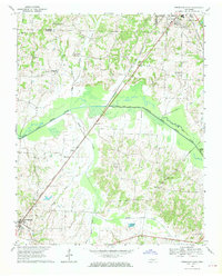 1967 Trezevant East1969 Print · USGSCarroll County in the late sixties reveals a landscape of river-bottom farms and rail-line settlements. Genealogists can trace local roots through St Johns Cem, New Zion, and family-named landmarks like Presely Lake.2 unique versions available
 - 1967 Map of Mc Kenzie, 1969 Print
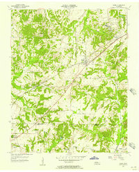
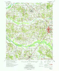
 1967 Mc Kenzie1969 Print · USGSThe rural landscape around McKenzie and Gleason is captured here in the late sixties, where three counties meet along the Louisville and Nashville line. Researchers can trace the grounds of Bethel College and find local landmarks like Tumbling Creek Cem and Everett Chapel.2 unique versions available
 - 1977 Map of McKenzie
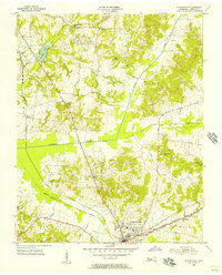
 1977 McKenzie1977 Print · USGSWest Tennessee rail and river networks converge at McKenzie during the mid-seventies, showing the region's transition into the modern era. Genealogists and historians can trace family locations near Bethel College, the rural Stafford Store, or old country sites like Christmasville.
 - 1986 Map of McKenzie
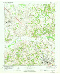
 1986 McKenzie1986 Print · USGSWest Tennessee in the mid-eighties was a landscape defined by its deep river forks and the massive waters of Kentucky Lake. Researchers can trace the rail lines of the Louisville & Nashville RR and find local landmarks from Skullbone to the Paris Landing State Park.3 unique versions available
End of results
Showing maps 1-7 of 7
Top cities near McKenzie
- Paris historical maps
- Huntingdon historical maps
- Dresden historical maps
- Gleason historical maps
- Atwood historical maps
- Hollow Rock historical maps
See more
Frequently asked questions
- What are the different types of historical maps available for McKenzie?
- What is the oldest map of McKenzie?
- Where can I purchase historical maps of McKenzie for my home or office?
- Where can I download high-res historical maps of McKenzie?
- Are there historical topographic maps available for McKenzie?
- Is there historical aerial imagery available for McKenzie?
- Where are historical maps of McKenzie sourced from?