1960s Maps of Ashland City, Tennessee
Explore 2 historic maps of Ashland City from the 1960s. These maps offer a rare glimpse into what life looked like during the 1960s — showing old roads, neighborhoods, homes, and landmarks that have changed or disappeared over time.
Whether you're researching your family's past, planning a metal detecting trip, or studying how Ashland City's landscape evolved across the 1960s, these high-resolution maps are a powerful tool for exploring the history of this region.
- Focus on a specific era: All maps on this page are from the 1960s, giving you a focused view of this time period.
- See what’s changed: Compare century-old streets, trails, and buildings to today's modern landscape using overlays and satellite layers.
- Research with precision: Use these maps for genealogy, historical research, land use analysis, or educational projects.
- View, download, or print: Maps are fully viewable online in high resolution, and can be downloaded or printed for your own records.
Start exploring Ashland City's history through authentic maps from the 1960s. This is your window into the past.
Ashland City, TN maps
(2)- 1966 Map of Lillamay, 1967 Print
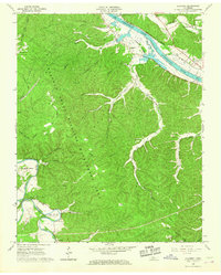 1966 Lillamay1967 Print · USGSThe Harpeth and Cumberland rivers frame this 1960s landscape of managed wilds and ancient sites. Genealogists and historians can trace Indian Mounds at Mound Bottom and local landmarks like Sams Creek Ch and Scott Cem.3 unique versions available
 - 1968 Map of Scottsboro, 1970 Print
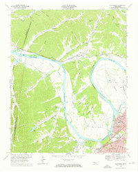 1968 Scottsboro1970 Print · USGSThe Cumberland River loops west of Nashville in the late sixties as suburban growth meets the rural bends. Trace the river economy via Cleeces Ferry and the Illinois Central Railroad, or find the massive State Penitentiary at Cockrill Bend.4 unique versions available
End of results
Showing maps 1-2 of 2
Top cities near Ashland City
- Nashville historical maps
- Clarksville historical maps
- Brentwood historical maps
- North Nashville historical maps
- Springfield historical maps
- Fairview historical maps
See more
Top neighborhoods of Ashland City
Frequently asked questions
- What are the different types of historical maps available for Ashland City?
- What is the oldest map of Ashland City?
- Where can I purchase historical maps of Ashland City for my home or office?
- Where can I download high-res historical maps of Ashland City?
- Are there historical topographic maps available for Ashland City?
- Is there historical aerial imagery available for Ashland City?
- Where are historical maps of Ashland City sourced from?