1940s Maps of Howard Quarter, Tennessee
Explore 2 historic maps of Howard Quarter from the 1940s. These maps offer a rare glimpse into what life looked like during the 1940s — showing old roads, neighborhoods, homes, and landmarks that have changed or disappeared over time.
Whether you're researching your family's past, planning a metal detecting trip, or studying how Howard Quarter's landscape evolved across the 1940s, these high-resolution maps are a powerful tool for exploring the history of this region.
- Focus on a specific era: All maps on this page are from the 1940s, giving you a focused view of this time period.
- See what’s changed: Compare century-old streets, trails, and buildings to today's modern landscape using overlays and satellite layers.
- Research with precision: Use these maps for genealogy, historical research, land use analysis, or educational projects.
- View, download, or print: Maps are fully viewable online in high resolution, and can be downloaded or printed for your own records.
Start exploring Howard Quarter's history through authentic maps from the 1940s. This is your window into the past.
Howard Quarter, TN maps
(2)- 1942 Map of Howard Quarter, 1957 Print
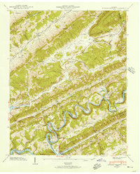 1942 Howard Quarter1957 Print · USGSThe borderlands of Claiborne and Hancock counties are shown here in the early 1940s as the Norris Reservoir transformed the winding Clinch River. Genealogists can trace family landmarks and rural life at Howard Quarter, Seal Chapel, and Mallicoat Cem.2 unique versions available
 - 1943 Map of Howard Quarter, 1946 Print
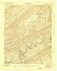 1943 Howard Quarter1946 Print · USGSMid-century Claiborne and Grainger Counties are defined here by the winding Clinch River and the early influence of the Norris Reservoir. Researchers can trace ancestral sites like Pearson Cem and old community hubs including Howard Quarter Sch and Seal Chapel.2 unique versions available
End of results
Showing maps 1-2 of 2
Top cities near Howard Quarter
- Morristown historical maps
- Harrogate historical maps
- Bean Station historical maps
- New Tazewell historical maps
- Tazewell historical maps
- Sneedville historical maps
See more
Frequently asked questions
- What are the different types of historical maps available for Howard Quarter?
- What is the oldest map of Howard Quarter?
- Where can I purchase historical maps of Howard Quarter for my home or office?
- Where can I download high-res historical maps of Howard Quarter?
- Are there historical topographic maps available for Howard Quarter?
- Is there historical aerial imagery available for Howard Quarter?
- Where are historical maps of Howard Quarter sourced from?